It's finally Friday and the forecast calls for another fabulous day with sunny and dry conditions prevailing.
TODAY: Partly sunny, with highs in the upper 60s to lower 70s. Winds from the NE at 5 to 10 mph.
TONIGHT: Partly cloudy, with lows in the lower to mid 40s. Winds generally calm.
TOMORROW: Sunny, with highs in the lower 70s. Winds from the E at 5 mph.
ATLANTIC TROPICS
- A large cluster of clouds from a system to the east of Caribbean is being watched for possible tropical cyclone development. Models are not doing much with it at the moment. NHC calls for a 10% chance of forming in the next 48 hours. I tend to agree.
 |
| The quiet continues in the tropics |
NATIONAL WEATHER
- Sunny, dry in the Northeast
- Showers along the coastlines of the Southeast from the coastal storm moving away. Otherwise, dry and gorgeous
- Warm across the South and Midwest
- Chilly in the Mountain West with rain in parts of the Northwest today
WORLD WEATHER
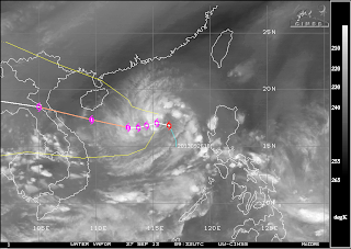
- Tropical Storm Wutip formed in the South China Sea and could impact Hainan, China and Vietnam as a typhoon starting next week.
- Rain showers and storms from the counter-clockwise spinning powerful low nearing Western Europe
- Aussie weather consists of storms in the southeast region, also another low impacting the South Island of New Zealand
 |
| Water vapor with track overlay for Tropical Storm Wutip. Tropical threat looming for Hainan, China and Vietnam next week. |
EARTHQUAKES
- There were no earthquakes rated at or above M6 yesterday or so far today.
SPACE WEATHER
- SpaceWeather.com is declaring this solar max is the weakest in 100 years. Sunspots on the visible solar disk are turning away and pose no threats for strong solar flares.
 |
| "Weakest Solar Max in 100 years", says SpaceWeather.com |
No comments:
Post a Comment