A little bit warmer than yesterday...nice for late September with temps into the upper 60s. Enjoy!
TODAY: Sunny with highs in the mid to upper 60s. Winds from the NW at 5 to 15 mph.
TONIGHT: Clear, with lows in the upper 30s to lower 40s. Light winds.
TOMORROW: Sunny, with highs in the upper 60s to lower 70s. Winds from the N at 5 to 10 mph.
Monitoring the possibility of an early-week storm to enter the month of October. Details early but could be one that runs up the coast bringing in tropical moisture. We'll see how models handle it in the coming days.
ATLANTIC TROPICS
- The Atlantic is quiet but the remnants of 95L are currently drenching Florida and have a chance at organizing once it enters the waters of the SE coast.
NATIONAL WEATHER
- Nice in the Northeast and Great Lakes
- Numerous downpours affecting the Gulf states and Florida. Flooding is possible.
- Mainly pleasant weather in the Midwest
- Showers and storms in the Northwest
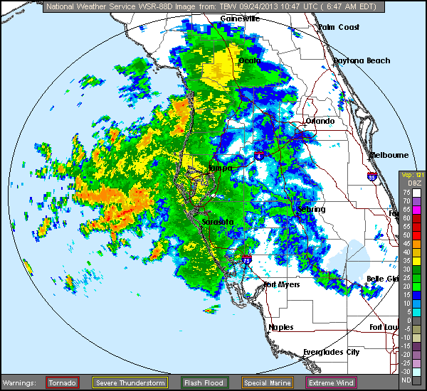 |
| Tropical moisture induced storms impacting Florida. Flood Watch for much of the state. |
WORLD WEATHER
- The lone tropical cyclone in the world, Typhoon Pabuk, in the Western Pacific is going to take a hard right away from Japan.
- Slowly clearing out with showers moving northeast in Europe
- Storms have been hammering New Zealand, while storms are keeping south of Australia
 |
| Pabuk stays away from Japan (Credit: Wunderground) |
EARTHQUAKES
- There were no earthquakes rated at or above M6 yesterday or so far today.
SPACE WEATHER
- Same story - solar activity on the low side once again. Sunspots aren't particularly interesting. Solar wind speeds have risen signaling the approach of a coronal hole solar wind stream meaning auroras for the polar regions.
No comments:
Post a Comment