It's shaping up to be a wonderful weekend. Enjoy!
TODAY: Sunny with highs in the mid 70s to near 80 degrees. Winds from the N at 5 mph.
TONIGHT: Cool night with temperatures dipping into the mid to upper 40s. Calm wind.
TOMORROW: After a cool morning, it will be sunny with highs in the mid 70s to near 80 degrees. Winds from the SW at 5 to 10 mph.
ATLANTIC TROPICS
- There are two areas of interests highlighted by the NHC but chances of development are currently low for both of them. Invest 95L in the Yucatan is the one marked as 20%.
- Still watching the tropical wave coming off of Africa which could develop in the long run. Though none of the reliable models develop it except for the CMC. Chances are very low.
NATIONAL WEATHER
- High pressure overhead means dry and sunny weather for the Northeast and Mid-Atlantic
- Humid and thunderstorms in the Southeast with the lagging front
- Hot in the heart of the country
- Moist flow from the Pacific delivering storms for the Southwest
- Dry in the West Coast and isolated thunderstorms in the Northwest
WORLD WEATHER
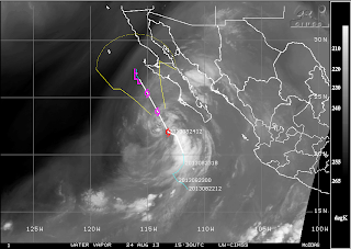
- The main storm in the Pacific is Tropical Storm Ivo who has eyes on Baja California where warnings are up. It's going to bring much-needed rain for drought-stricken regions in the Southwest.
- Pewa is down to a depression and should go poof soon.
- Possible storms in central Europe
- Isolated showers in southern parts of Australia while sunny and dry for the rest.
EARTHQUAKES
- There were no earthquakes rated at or above M6 yesterday or so far today.
SPACE WEATHER
- Still waiting a CME that is supposed to glance Earth's magnetic field anytime soon. This will likely trigger a geomagnetic storm this weekend.
- High solar winds from a coronal hole stream facing Earth is due to arrive by early next week.
- The sun is back on the low end. Sunspots are weakening and overall solar activity is very low as we approach the maximum due at the end of the year.

No comments:
Post a Comment