High pressure moves offshore and a cold front from the Great Lakes will move in here during the afternoon and evening hours. Showers and storms ahead of the front poses a threat for flooding in the heaviest downpours. Due to a strong jet and modest wind shear values, an isolated severe storm is possible. Though with insufficient instability and heating, a more scattered to widespread threat is not expected. Flooding is the main issue with this storm system.
TODAY: Showers and thunderstorms likely. Humid with dewpoints near 70. Highs to the mid to upper 70s. Winds from the SW at 5 to 10 mph.
TONIGHT: Lingering showers and storms early then clearing out after midnight. Patchy fog developing. Lows in the mid 50s. Winds turning from SW to NW at 5 to 10 mph.
TOMORROW: Beautiful day. Mostly sunny with highs in the lower to mid 70s. Winds from the NW at 5 to 15 mph.
After Tuesday's rain, indications are the rest of the week is dry and seasonable.
NATIONAL WEATHER
- Showers and thunderstorms in the Northeast and Mid-Atlantic. A few could be strong to severe.
- Downpours and storms continue for the Midwest, Gulf Coast, and Southeastern states
- Isolated thunderstorms in the Southwest
- Dry and sunny in the Upper Midwest
- Hotter weather as ridge builds in the Pacific Northwest
- There's an area of interest in the Caribbean that models are developing into a tropical cyclone by the end of the week. Interests in Gulf should monitor.
WORLD WEATHER
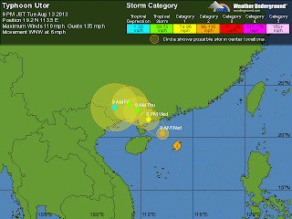
- Typhoon Utor remains a serious threat for China, now rated Category 2 with winds at 110 mph in the South China Sea. It looks to make landfall southwest of Hong Kong:
 |
| Typhoon Udor's projected track. Projected to make landfall in China tomorrow evening around 9PM EDT. |
- Utor has been blamed for at least 4 deaths in the northern Philippines.
- Gorgeous weather for the most part in Europe. Scattered storms in the central part of the continent.
- Dry conditions in North Australia while cold front with associated trough brings showers in the southern region.
EARTHQUAKES
There were no earthquakes rated at or above M6 yesterday or so far today.
SPACE WEATHER
Sunspots 1817 and 1818 poses a threat for M-class and X-class solar flares. NOAA forecasters are estimating a 30% chance of M-class flares and a 5% chance of X-class flares today. A solar wind stream from a coronal hole should reach Earth on August 15-16.
 |
| Courtesy of http://www.spaceweather.com |
No comments:
Post a Comment