Saturday, August 31, 2013

8/31/2013 Daily Update: Dreary Saturday, Showery and Stormy Labor Day Weekend, 7.0 Earthquake Alaska

Good afternoon everyone!

Labor Day weekend starts today and the forecast isn't the best with showers and storms possible each day of the 3-day holiday. But it won't be totally bad, just be prepared in case it rains.

TODAY: Mostly cloudy with a chance of showers and storms throughout the day. Higher chances of storms in the afternoon. Highs in the lower 80s. Winds from the SW at 5 to 10 mph.

TONIGHT: Mostly cloudy with patchy fog developing, along with shower and storm chances. Lows in the mid to upper 60s. Winds from the SW at 5 mph.

TOMORROW: Partly sunny with showers and storms possible again anytime during the day. Highs in the lower 80s. Winds from the SW at 5 to 10 mph.

Labor Day on Monday continues the stormy trend, perhaps more numerous than Saturday and Sunday.


ATLANTIC TROPICS

  • A developing tropical wave located off the coast of Africa has a decent chance of being named Gabrielle. It's heading straight at the Cape Verde Islands who will see some nasty weather with it strengthening over the area. NHC has a 40% chance of development in the next 48 hours.
  • Tropical wave in the Central Atlantic slowly and steadily making its way toward the Caribbean where it should encounter higher sea surface temperatures. Whether or not it picks up convection and organizes remains to be seen. Still 4-7 days away for any true signs. The reliable models continue to do nothing with it though.
Two areas of interests today in the Atlantic

NATIONAL WEATHER

  • Stormy across the Northeast today
  • Also, storms in the Southeast as usual.
  • Heat wave continues for the Midwest and the South
  • Strong to severe storms possible in the Upper Midwest
  • Some storms for the Southwest
  • Dry and warm for the Northwest with high pressure, cooler along the California coast with onshore flow

WORLD WEATHER

  • Kong-rey succombing to cooler waters along the Japanese coastline and making impacts felt only as a weak tropical depression.
  • Tropical Depression Eleven-e has formed in the Eastern Pacific pretty far away from the Baja Peninsula
  • Storms for parts of central and eastern Europe with the low over land
  • Cold front producing showers in Southwest Australia, showers clearing in the southeast, dry in the interior and north

EARTHQUAKES


SPACE WEATHER

  • A CME from the C8-class flare yesterday is expected to make a glancing hit at Earth's magnetic field sparking a minor geomagnetic storm on September 1st.
  • M-class flare chances are low at 1%.

Friday, August 30, 2013

8/30/2013 Daily Update: More Sun Today, 3 Killed in Taiwan From Kong-rey

Good morning everyone and Happy Friday!

Yesterday featured more clouds than sun but it was dry. Today is going to be the opposite - with more sun than clouds.

TODAY: Partly to mostly sunny with highs in the lower 80s. Winds from the SW at 5 mph.

TONIGHT: Mostly cloudy with lows in the lower 60s. Winds from S at 5 mph.

TOMORROW: Mostly cloudy with a chance of thunderstorms in the afternoon. Highs in the lower 80s. Winds from the SW at 5 to 10 mph.

Turning stormy heading into the weekend. Looking like chances of storms each day from Saturday to Tuesday.


ATLANTIC TROPICS

  • Keeping tabs with the tropical wave in the Central Atlantic. NHC keeps chances at 10% for development.
  • A large and pretty impressive wave coming out of Africa is designated Invest 96L and has a good chance of developing over the next couple of days. NHC - 40% chance at 48 hrs, 60% chance in 5 days

NATIONAL WEATHER

  • Warmer across the Northeast from high pressure
  • Stormy in the Southeast once again
  • Very hot in the Midwest and South. A heat wave continues to grip the region.
  • Strong to severe thunderstorms possible for the Dakotas
  • Few PM thunderstorms possible in the Southwest
  • Sunny and dry in the West Coast

WORLD WEATHER

  • Kong-rey is a tropical depression dashing toward Japan after impacting Taiwan and brought heavy rains for the island country reeling from effects of Trami last week. 3 are confirmed dead in Taiwan. http://www.scmp.com/news/china/article/1300609/tropical-storm-kong-rey-kills-three-taiwan
  • Juliette has become post-tropical out in the Eastern Pacific.
  • Cloudy across northeastern and eastern parts of Europe, spotty t-storms in the South otherwise mostly dry
  • Australian weather has been on repeat every single day with high to the north and showers to the south.
Track of Kong-rey expected to impact Japan tomorrow

EARTHQUAKES

  • There were no earthquakes rated at or above M6 yesterday or so far today.

SPACE WEATHER

  • Coronal hole stream facing Earth will lead to faster solar wind speeds.
  • A C8.3-class flare erupted from Sunspot 1836 last night and is the main focus for additional flares today. A CME was also seen which is expected to make a glancing blow this weekend. Aurora watch for high-latitudes.
  • M-class flare chances today: 1%
Sunspot 1836 harbors energy for M-class
flares after a C8.3 flare last night. (Courtesy:
spaceweather.com)

Thursday, August 29, 2013

8/29/2013 Daily Update: Partly Sunny Thursday, Juliette Forms Along Baja California, Kong-rey Swipes Taiwan

Good afternoon everyone!

After a round of storms yesterday which brought localized flooding in places, today is going to feature less in the way of storms but still possible anytime in the afternoon.

TODAY: Partly sunny with a few showers and storms possible in the PM hours. Highs in the upper 70s, near 80 degrees. Winds from the NE at 5 mph.

TONIGHT: Mostly cloudy with lows around 60 degrees. Winds from the E at 5 mph, becoming calm.

TOMORROW: Beautiful day with most sunny skies. Highs in the low 80s. Winds from the W at 5 mph.

After a brief respite Friday, the weekend features a second round of storms, especially late Sunday.


ATLANTIC TROPICS

  • Fairly quiet in the tropics though there are two waves to monitor. First, is the open wave in the Central Atlantic which is expected to track into the Caribbean in the coming days where it should encounter somewhat, more favorable place for it to develop. Model support has mostly vanished though but I still think it can do something with what it has. The 0z NAVGEM shows a tropical cyclone in 144 hours over the Lesser Antilles. In my opinion, this certainly remains a possibility.
  • Secondly is the wave over Africa that NHC has marked for tropical development over land for the first time. It has a 10% chance of development in the next 48 hours which is reasonable since it really hasn't touched water yet. Past runs of the GFS had shown a tropical cyclone from this one but has dropped the idea.

NATIONAL WEATHER

  • Isolated storms in New England, dry elsewhere in the Northeast
  • Storms possible in the Southeast, otherwise mostly hot there
  • The heat in the central part of the nation continues. Hot, hot, hot!
  • Severe thunderstorms are possible in the Minnesota, Wisconsin area.
  • T-storms in the afternoon for the Southwest
  • Sunny across the West Coast, storms in the far Pacific Northwest

WORLD WEATHER

  • Tropical Storm Juliette formed right on the southern tip of the Baja California peninsula. It's going to result in heavy rains and moisture feeding into the rains occurring in the Southwest.
  • Tropical Storm Kong-rey has shaved the eastern coast of Taiwan and is now heading toward Japan.
  • Thunderstorms for eastern Europe
  • Severe thunderstorms possible across Southeast Australia. Showers and storms impacting southern regions.
Water vapor of Tropical Storm Kong-rey
along Taiwan
Tropical Storm Juliette skimming Baja California

EARTHQUAKES

  • There were no earthquakes rated at or above M6 yesterday or so far today.

SPACE WEATHER

  • A large filament erupted from the sun and generated a CME. It was directed mostly south of Earth but a piece of it may make it. We'll see.
  • Meanwhile, sunspots aren't actively flaring and M-class flare chances are at 1%.

Wednesday, August 28, 2013

8/28/2013 Daily Update: Partly Sunny, Scattered Storms Today, Tropical Storm Kong-rey

Good morning everyone!

Let's dive into the forecast, shall we...

TODAY: Partly sunny with scattered storms in the afternoon. Humid too. Highs in the lower to mid 80s. Winds from the SE at 5 mph.

TONIGHT: Chance of a pop-up shower or storm, otherwise mostly cloudy. Lows dropping in the upper 50s to lower 60s. Generally calm winds.

TOMORROW: Partly sunny with a small chance of an afternoon shower or storm again. Highs will be in the lower 80s. Winds from the NW at 5 mph.

Looking pretty nice for the Labor Day weekend, although can't rule out a spot shower late Sunday where things start to turn unsettled around here next week.


ATLANTIC TROPICS

  • Interesting feature in South Florida with an upper-level low spinning off the coast as evident on the visible below.
  • The tropical wave in the Central Atlantic is moving west and there remains a small chance for development.
  • Another one moving out of Africa could start to develop once it's over water. It's expected to move over the Cape Verde islands and a high chance of it moving out to sea thereafter.

NATIONAL WEATHER

  • Scattered storm threats continue for the Northeast
  • Dry and warm for the Southeast with the exception of Southern Florida where they are dealing with storms associated with the upper-level low spinning near the coast
  • Big high pressure and hot weather persists over the Midwest and the South
  • Some heavy rain possible for the Southeast dealing with the after-effects of Ivo
  • Dry and sunny along the West Coast

WORLD WEATHER

  • Tropical Kong-rey is taking a close swipe at Taiwan and could impact Japan by the weekend.
  • Storms continue for central Europe with the low pressure convergence over there.
  • Australia's weather has seen almost no difference in the last two weeks with the high pressure to the north bringing fair weather while fronts cross the south bringing chances of showers and storms.

EARTHQUAKES


SPACE WEATHER

  • The Kp index did rise to 5 due to a coronal hole stream facing Earth.
  • A CME was visible this morning but was not toward Earth.
  • Solar activity is low with M-class flare chances down to 1%.

Tuesday, August 27, 2013

8/27/2013 Daily Update: Slight Chance of Shower/Storm Today, 13 People Dead From Fernand

Good morning everyone!

Rain, even heavy at times, overnight has cleared but we do run a chance of a slight chance of a shower or storm in the afternoon.

TODAY: Partly sunny with a small chance of a shower or storm in the afternoon. Highs will be in the lower to mid 80s. Winds from the N at 5 to 10 mph.

TONIGHT: Isolated shower or storm possible, otherwise mostly cloudy skies. Lows in the lower 60s. Generally light winds.

TOMORROW: Partly sunny skies with a shot at storms in the afternoon. Highs in the lower 80s. Winds from the N at 5 mph.

Thinking better shot of storms on Wednesday west, whereas on Thursday better shot shifts east.


ATLANTIC TROPICS

  • The tropical wave couple hundred miles from the Cape Verde Islands that's been mentioned is in an area of slightly favorable conditions but dry air on the north-side is hindering progress. After a few "optimistic" runs, the GFS doesn't do squat about this puppy. However, the ECMWF and the CMC does show development in 7-days time once it nears the Lesser Antilles. Something to watch.
  • The GFS does show interest with another tropical wave about to come out of Africa and has been consistent on development in the next 5 days. Based on the path shown on the GFS, there's a high likelihood this one recurves out to sea. (Image below)
This morning's 6z GFS run at 120 hours showing
a tropical cyclone over the Cape Verde Islands

NATIONAL WEATHER

  • Spotty thunderstorms persist in the Great Lakes and Northeast. Possible strong to severe storms along Wisconsin, Minnesota, and Michigan.
  • Dry and warmer in the Southeast though storms possible along the Florida coast
  • High pressure in the Midwest means hot and dry conditions. Temperatures above 90 but factoring in the humidity, it will feel more than 100 degrees.
  • Heavy rain and thunderstorms in the Southwest present flash flooding threats as the effects of Ivo are being felt.
  • Sunny weather for the West Coast

WORLD WEATHER

  • At least 13 people dead after Tropical Storm Fernand made landfall in central Mexico from torrential rains triggering deadly landslides, making Fernand the deadliest storm of the 2013 season so far. http://www.reuters.com/article/2013/08/27/us-storm-fernand-idUSBRE97P0QE20130827
  • Tropical Storm Kong-rey in the Western Pacific is making a close swipe at Taiwan, tracking toward Japan by the end of the week.
  • Low pressure bringing storms in central and southeastern Europe
  • Low producing showers and storms for southern parts of Australia, rest remains dry.

EARTHQUAKES


SPACE WEATHER

  • Earth is facing a coronal hole stream set to arrive by this weekend.
  • Not much going on with the sun. The largest of the sunspots, 1835, is fairly decent-sized but remains quiet for now. Chances of M-class flares are very low at 1%.
Sunspots are either stable or decaying
(Courtesy: spaceweather.com)

Monday, August 26, 2013

8/26/2013 Daily Update: Shower Chances Today, Fernand One and Done

Good afternoon everyone!

Today we will have to contend with on and off showers. Won't be a washout but it would be wise to grab an umbrella in case. More widespread rains tonight with rumbles possible.

TODAY: Cloudy conditions with scattered showers throughout the day. Highs in the upper 70s to low 80s. Winds from the SW at 5 to 10 mph.

TONIGHT: Scattered showers continue into the evening. Perhaps a few storms if we're lucky. Mostly cloudy with lows in the lower to mid 60s. Winds from the W at 5 mph becoming calm.

TOMORROW: Partly sunny with a slight chance of an afternoon shower or storm. Highs in the lower to mid 80s. Winds from the NW at 5 mph.

Showers and storm threats last into Wednesday before calmer weather arrives starting Thursday into Labor Day weekend.


ATLANTIC TROPICS

  • Tropical Storm Fernand was formed yesterday and has made landfall in Mexico. Now down to a depression. As quickly as he was named, he will be downgraded to a remnant low just as quick.
  • Tropical wave in the Eastern Atlantic will need time to develop.

NATIONAL WEATHER

  • After a beautiful weekend, scattered thunderstorms arrives in the Northeast ahead of a trailing cold front in the Great Lakes region.
  • Big heat dome across the central portion of the country. Temps soar above 90 degrees and near 100 for parts of the Midwest.
  • Tropical moisture in the Gulf feeding into storms across the Gulf and Florida coast.
  • Generally dry in the Southeast except for Florida
  • Rain for the Southwest from remnants of Ivo
  • Mostly dry and pleasant up and down the West Coast

WORLD WEATHER

  • Tropical Storm Fernand making landfall in Mexico, down to a depression.
  • Tropical Storm Kong-rey has formed in the Western Pacific east of the Philippines moving north with Taiwan in the crosshairs again.
  • Good news - Pewa is gone.
  • Thunderstorms along southeastern Europe from a low pressure system.
  • Few storms for Tasmania and southern parts of Western Australia. Otherwise, high keeps rest of the area dry and seasonable.

EARTHQUAKES
  • There were no earthquakes rated at or above M6 yesterday or so far today, unfortunately. (fortunately?)

SPACE WEATHER

  • CMEs from the weekend have disappointed and impacts were barely felt, if at all.
  • Solar activity is currently very low with M-class flare chances down to 1%.

Sunday, August 25, 2013

8/25/2013 Daily Update: Ending the Weekend on a Bright Note, Stormy to Start Week, Emergence of Cape Verde Season?

Good morning everyone!

After a cool morning, it's going to be another flawless day, get out and enjoy your Sunday if you can!

TODAY: Sunny with highs in the upper 70s to lower 80s. Winds from the SW at 5 to 10 mph.

TONIGHT: Mostly clear with lows in the mid to upper 50s. Winds from the SW at 5 mph.

TOMORROW: Partly to mostly cloudy with afternoon showers and storms. Highs in the mid to upper 70s. Winds from the S to SW at 5 to 15 mph.

Storm chances arrive starting Monday for the next 3 days. Wednesday does hold a small potential of a severe thunderstorm threat. Details won't be ironed out until closer to the date. Though, looking down the road, the second half of the week should feature beautiful weather heading into Labor Day weekend.


ATLANTIC TROPICS

  • The wave in the Yucatan Peninsula is becoming better organized and developing convection around the center. Being close to land will hinder the system, though it does have a chance of being upgraded to a depression today as it spends time over the hot Gulf water. NHC tags the wave with a red circle and a 60% chance of developing in the next 48 hours. I say it is more like 40%.
  • Watching a decent tropical wave coming off of Africa which could signal the emergence of the Cape Verde season we've all been anticipating. Latest models have been developing this into a tropical cyclone once it crosses west of 45°W longitude. Climatologically, this is around peak season for long-trackers which are usually the most intense hurricanes of a given season.
Water vapor of the tropical wave about
to enter the Eastern Atlantic

NATIONAL WEATHER

  • Fantastic weather for the Northeast after a cool morning
  • Rain and storms continue to strike the Southeast
  • Disturbance in the Gulf could trigger storms along the Gulf Coast and bring much-needed rain in drought-stricken areas like South Texas where they are in a extreme to exceptional drought.
  • High over the Plains means warm weather for them.
  • Moisture from what is left of Ivo brings the potential for flooding rains for the Southwest. Some drought relief is in store but too much in a short time is not good.
  • Dry in the West Coast, scattered thunderstorms possible for the Northwest

WORLD WEATHER

  • Ivo is a depression and about to dissipate soon. His moisture are going to affect Baja California and the Southwest.
  • For the second straight time, Pewa should go poof soon.
  • Scattered storms across south-central Europe
  • Heavy thunderstorms possible for Western Western Australia (yes, I did mean to say that), showers for Tasmania and Southern Victoria.

EARTHQUAKES


SPACE WEATHER

  • Very weak impact from the CME yesterday, barely registering at all. Well, we do have another chance with a second one today. NOAA forecasters have geomagnetic storm chances up to 75% today.
  • High solar winds from a coronal hole stream facing Earth is due to arrive by early next week.
  • Solar activity is very low. M-flare chances down to 5% in the next 24 hours, possibly going down to 1% by tomorrow.

Saturday, August 24, 2013

8/24/2013 Daily Update: Wonderful Weekend, Ivo Approaching Baja California

Good morning everyone!

It's shaping up to be a wonderful weekend. Enjoy!

TODAY: Sunny with highs in the mid 70s to near 80 degrees. Winds from the N at 5 mph.

TONIGHT: Cool night with temperatures dipping into the mid to upper 40s. Calm wind.

TOMORROW: After a cool morning, it will be sunny with highs in the mid 70s to near 80 degrees. Winds from the SW at 5 to 10 mph.


ATLANTIC TROPICS

  • There are two areas of interests highlighted by the NHC but chances of development are currently low for both of them. Invest 95L in the Yucatan is the one marked as 20%.
  • Still watching the tropical wave coming off of Africa which could develop in the long run. Though none of the reliable models develop it except for the CMC. Chances are very low.

NATIONAL WEATHER

  • High pressure overhead means dry and sunny weather for the Northeast and Mid-Atlantic
  • Humid and thunderstorms in the Southeast with the lagging front
  • Hot in the heart of the country
  • Moist flow from the Pacific delivering storms for the Southwest
  • Dry in the West Coast and isolated thunderstorms in the Northwest

WORLD WEATHER

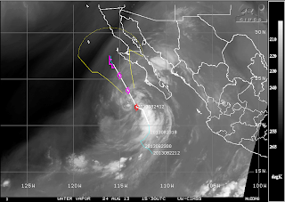
  • The main storm in the Pacific is Tropical Storm Ivo who has eyes on Baja California where warnings are up. It's going to bring much-needed rain for drought-stricken regions in the Southwest.
  • Pewa is down to a depression and should go poof soon.
  • Possible storms in central Europe
  • Isolated showers in southern parts of Australia while sunny and dry for the rest.
Water vapor of Tropical Storm Ivo
nearing Baja California

EARTHQUAKES

  • There were no earthquakes rated at or above M6 yesterday or so far today.

SPACE WEATHER

  • Still waiting a CME that is supposed to glance Earth's magnetic field anytime soon. This will likely trigger a geomagnetic storm this weekend.
  • High solar winds from a coronal hole stream facing Earth is due to arrive by early next week.
  • The sun is back on the low end. Sunspots are weakening and overall solar activity is very low as we approach the maximum due at the end of the year.

Friday, August 23, 2013

8/23/2013 Daily Update: Mostly Sunny Friday, Tropical Storm Ivo

Good morning everyone!

After showers and storms last night, it will be generally dry today except for a small chance of an isolated shower or storm possible.

TODAY: Mostly sunny with a very small chance of an isolated shower or storm. Highs in the lower to mid 80s. Winds from the N at 5-15 mph.

TONIGHT: Mostly clear with lows in the lower to mid 50s. Winds becoming calm overnight.

TOMORROW: Cooler and comfortable conditions. Sunny with highs ranging between mid 70s to near 80. Winds from the N at around 5 mph.

A gorgeous weekend is shaping up!

ATLANTIC TROPICS

  • A disturbance in the NE Gulf of Mexico associated with a weak trough should present no threats in terms of tropical cyclone development. NHC only tags it with a 10% chance in the next 48 hours.
  • There is a wave coming off of Africa but it does not look prime for development.

NATIONAL WEATHER

  • Cold front passage is bringing refreshing air for the Northeast. Scattered storm threat drops south into the southern Mid-Atlantic region.
  • Scattered afternoon storms and humidity continue for the Southeast
  • Hot weather in the south all the way up to the Plains. Surge of heat in the central part of the nation.
  • Dry and seasonable in the West Coast. Cooler in the Northwest from low off the coast.

WORLD WEATHER

  • Tropical Storm Ivo has formed in the Eastern Pacific and its on path to come near the Baja Peninsula heading north.
  • Tropical Storm Pewa has degenerated into a depression in the Western Pacific with no danger to land.
  • Low south of Iceland is bringing showery and cloudy conditions ahead of it. Clouds in NE Europe otherwise mostly sunny and dry.
  • A weak trough is bringing isolated showers for Southeastern Australia. Otherwise mainly dry conditions elsewhere.

EARTHQUAKES

  • There were no earthquakes rated at or above M6 yesterday or so far today.

SPACE WEATHER

  • These two CMEs are set to arrive today or tomorrow. Be on alert for auroras in high latitudes.
  • High solar winds from a coronal hole stream facing Earth is due to arrive by early next week.
  • The Earth is experiencing minor geomagnetic disturbances with the Kp Index rising to 4 over the last few days.
  • Quiet sun with no sunspots posing a threat for strong solar flares. M-flare chances are at 10% in the next 24 hours.

Thursday, August 22, 2013

8/22/2013 Daily Update: Few PM Storms Possible, Double CME Impacts Expected

Good afternoon everyone!

Some changes to the forecast with afternoon thunderstorms possible. Today is going to be the most humid day in the stretch before cooler conditions return for the weekend.

TODAY: Partly sunny with showers and storms in the afternoon, a few of which could be strong in locales. Highs around mid 80s. Winds from the SW at 5 to 10 mph.

TONIGHT: Chance of storms continuing into the early evening hours, otherwise mostly cloudy skies with temps dropping into the lower to mid 60s. Winds becoming light overnight.

TOMORROW: Mostly sunny with a chance of an isolated afternoon storm. Highs in the upper 70s to lower 80s. Winds from the NW-N at 5 to 10 mph.

The weekend looks comfortable with temperatures in the 70s/80s with abundant sunshine!

ATLANTIC TROPICS

  • No development foreseen in the near future.

NATIONAL WEATHER

  • Hot and humid in the Northeast with scattered thunderstorms ahead of cold front to the NW
  • Unsettled in the Southeast with scattered thunderstorms
  • High pressure is bringing dry and sunny weather for the South and the heart of the nation
  • Sunny in the West with spotty thunderstorms possible. A few could be strong around Oregon.
  • Warmer air arriving to the Pacific Northwest

WORLD WEATHER

  • Typhoon Trami made landfall in the Southeastern Chinese coastline bringing heavy rain, strong winds, and flooding. No deaths were reported as of today but it did kill 17 people in Philippines as a result of the flooding.
  • Pewa is still out there in the Western Pacific and should not be a threat except for mariners.
  • Tropical Depression 9-E has formed in the Eastern Pacific and is expected to strengthen into a tropical storm soon. Next name on the list is Ivo. Could have impacts to the Baja Peninsula as early as Sunday.
  • 21 construction workers in Northwest China were killed from flash flooding. China has been plagued by flooding where hundreds have been killed recently. http://www.washingtonpost.com/world/asia_pacific/21-killed-by-flash-flood-at-northwest-china-construction-site-as-heavy-rains-batter-country/2013/08/21/2b8d64b2-0a23-11e3-89fe-abb4a5067014_story.html
  • Coastal low near the United Kingdom is bringing stormy weather for the nation. Isolated storms possible for the rest of Europe.
  • Consistent dry weather across the northern part of Australia while showers and storms affect the southern region.
NHC track of Tropical Depression Nine-e

EARTHQUAKES

  • There were no earthquakes rated at or above M6 yesterday or so far today.

SPACE WEATHER

  • The large filament that blasted from the sun on August 20th is set to make a glancing blow at Earth's magnetosphere tomorrow.
  • Another partial and faint halo CME yesterday was produced and expected to impact Earth by this weekend.
  • Sunspot 1827 poses a threat for M-class flares today, however chances are slim with a 10% chance of an M-class flare in the next 24 hours.
Courtesy of spaceweather.com

Wednesday, August 21, 2013

8/21/2013 Daily Update: Sunny and Summery Wednesday, Trami Impacts China/Taiwan

Good morning everyone!

A touch of summer is in the air with temperatures approaching 90 degrees today and tomorrow.

TODAY: Sunny with highs in the mid 80s for the hilltowns, approaching or eclipsing 90 in the valleys. Winds from the SW at 5 to 10 mph.

TONIGHT: Mostly clear with lows in the lower to mid 60s. Winds will be light.

TOMORROW: Partly to mostly sunny with afternoon storms. Turning more humid. Winds from the SW at 5 to 10 mph.

A cold front is slated to arrive late Thursday bringing slightly cooler air for Friday.

ATLANTIC TROPICS

  • The tropics is so quiet you can hear a pin drop. Like seriously.

NATIONAL WEATHER

  • Very warm and humid conditions in the Northeast. Locally severe storms in the Upper Midwest along Minnesota, Wisconsin, and Michigan from an impending cold front
  • Thunderstorms continue for the Southeast and Gulf Coast with moist flow from the Gulf of Mexico. 
  • Very warm and dry across the South and the Plains. Only exception is scattered storms in the Northern Plains.
  • Seasonal weather for the West Coast with isolated thunderstorms in the afternoon.
  • Dry and hot in the Pacific Northwest

WORLD WEATHER

  • Trami is now a typhoon in the Western Pacific destined to skim northern Taiwan and make landfall in China around Fuzhou.
  • Tropical Storm Pewa in the Western Pacific is meandering in no man's land.
  • There is development in the Eastern Pacific with two tropical waves closeby. Perhaps a Fujiwhara interaction between the two as shown on the GFS? We can only hope and watch, can we? Especially since the Atlantic is quiet...
  • Coastal low near the coast of the United Kingdom is bringing clouds and shower chances for the region. Isolated showers and storms in Eastern Europe otherwise dry.
  • Australia's weather has been on repeat with fronts bringing showers and storms crossing southern parts of the continent and New Zealand while rest of region remains dry.
Satellite view of Typhoon Trami. A nice developed eye can be seen
as the storm moves toward China.

EARTHQUAKES


SPACE WEATHER

  • The CME from last weekend has indeed glanced the Earth sparking a minor geomagnetic storm with the Kp-index rising to 4.
  • A filament erupted from the Sun yesterday morning and another CME is hurled at Earth's direction. Like last time, it is not direct. Regardless, any impacts should arrive in two days from now.
  • Solar activity is low but new Sunspot 1827 is capable of producing future solar flares.
Courtesy of spaceweather.com

Tuesday, August 20, 2013

8/20/2013 Daily Update: Near 90 Today, Philippines Flooding

Good afternoon everyone!

Temperatures are on the increase for the next few days with more humid air arriving from the south and the jet stream displaced north into Canada.

TODAY: Sunny with highs in the mid to upper 80s and near 90. Winds from the W at 5 to 10 mph.

TONIGHT: Clear with highs in the mid to upper 50s. Winds turning light overnight.

TOMORROW: Sunny skies with highs in the mid 80s and reaching 90 degrees especially in the valleys. Winds from the SW at 5 to 10 mph.

By Thursday afternoon/Friday, a cold front will swing through the region bringing storm chances and cooler air back in the forecast.

NATIONAL WEATHER

  • Sunny and dry in the Northeast with high pressure
  • Scattered thunderstorms in the Southeast. Humid.
  • Hot weather across the South and the Plains with few storms around
  • Nice weather for the West Coast and Pacific Northwest

WORLD WEATHER

  • Tropical Storm Trami in the Western Pacific is one to monitor as it is expected to impact Northern Taiwan tomorrow. Meanwhile, Pewa's strengthening died down abruptly but it is expected to strengthen back into a typhoon. Unala is gone and another tropical depression has taken shape in the Central Pacific.
  • Severe flooding in the Philippines from heavy monsoonal rains has killed at least 7 and tens of thousands are forced to evacuate. 70% of Manila, the nation's capital, is underwater. Schools, government offices, and financial markets, are closed. http://www.cnn.com/2013/08/20/world/asia/philippines-floods/
  • An isolated tornado touched down in Central Germany from yesterday's storms. Thankfully, that system is out of the way and shifted northeast but a next low and round of storms is heading toward the United Kingdom for tomorrow. Showers forecasted for Northeast Europe today.
  • Same story with showers affecting southern portions of Australia and New Zealand while high pressure remains firm for the rest of the continent.
Tornado report in Central Germany
(Source: http://hisz.rsoe.hu/alertmap/index2.php)

EARTHQUAKES

  • There were no earthquakes rated at or above M6 yesterday or so far today.

SPACE WEATHER

  • An off-target CME that blasted from the sun two days ago could still trigger a geomagnetic storm today or tomorrow.
  • A large halo CME blasted from the sun yesterday but the good news is it was on the far side of the sun and not Earth-facing. A cool spectacle can be seen on SOHO where a sundiving comet plunged into the sun and perishing the icy-cold body from the solar system. A neat image of the CME and sundiving comet is on spaceweather.com.
  • The sun is dotted with sunspots but none look too significant except for Sunspot 1825 which harbors energy for M-class flares. Percentage kept at 25% chance of a M-class flare in the next 24 hours.
Sunspot 1825 possesses energy for M-class
solar flares (Source: spaceweather.com)

Monday, August 19, 2013

8/19/2013 Daily Update: Warmer Monday, 90 Degrees by Midweek

Good morning everyone!

The coastal storm that brought us clouds yesterday has moved out allowing for sunshine today. It is going to be warmer and humidity is on the uptick as well.

TODAY: Warmer than yesterday. Mostly sunny with highs in the lower to mid 80s. Winds from the W at 5 to 10 mph.

TONIGHT: Mostly clear with lows in the mid to upper 50s. Winds from the W at 5 to 10 mph turning calm overnight.

TOMORROW: Sunny with highs in the lower to upper 80s. Winds from the W at 5 to 10 mph.

A good shot at 90 degrees on Tuesday and Wednesday as winds turn more to the southwest bringing in the warmer air!

ATLANTIC TROPICS

  • Lone source of development with a tropical wave off of Africa but NHC has since dropped the chances altogether.
  • Erin has dissipated from tropical cyclone status.

NATIONAL WEATHER

  • High pressure and dry weather for the Northeast. Few storms possible in the Mid-Atlantic.
  • Humid with more showers and storms in the Southeast. Hot but typical heat in the South.
  • Hot along the West Coast and the Plains. Many places will reach 90 degrees inland. That is the source of our heat come midweek.

WORLD WEATHER

  • The Pacific continues to light up with three storms in the Western Pacific basin.
  • Tropical Storm Trami in the Western Pacific is a threat for Taiwan and could meet typhoon criteria soon.  Typhoon Pewa is a Category 1 typhoon has open waters ahead and will have plenty of time to become even stronger.
  • Once Tropical Storm Unala is now a depression and looks to be short-lived due to shear.
  • Thunderstorms possible for Central Europe. Sunny and hot in Spain and parts of Eastern Europe as well.
  • Showers across southern parts of Australia while dry and seasonable elsewhere.

EARTHQUAKES

  • There were no earthquakes rated at or above M6 yesterday or so far today.

SPACE WEATHER

  • After two M-class flares two days ago, solar activity is back on the low side. We are awaiting an indirect CME impact from those flares which could happen as early as tomorrow.
  • Sunspots 1818 and 1824 have energy to produce M-flares. 25% chance of an M-flare in the next 24 hours.
Courtesy of spaceweather.com

Sunday, August 18, 2013

8/18/2013 Daily Update: Cloudy But OK Sunday, M3-class Flare

Good afternoon everyone!

Yesterday was great and today is going to be good but we'll have to contend with clouds. This is due to a storm system sliding south of the region.

TODAY: Cloudy with highs in the mid to upper 70s. Winds from the S at 5 mph.

TONIGHT: Mostly cloudy with lows in the lower to mid 50s. Generally calm winds.

TOMORROW: Warmer. Sunny with highs in the lower to mid 80s. Winds from the W-NW at 5 to 10 mph.

Looking like upper 80s Tuesday and 90s finally Wednesday and Thursday.

ATLANTIC TROPICS

  • Well, it's the end of Invest 92L. It showed some promising circulation at first but ultimately it remained disorganized and could never develop fully. However, the eastern flank of Invest 92L is producing heavy rain and flooding potential for the Gulf Coast states and the Southeast today.
  • Erin has weakened into a tropical depression and should degenerate soon.
  • Watching the wave coming off of Africa which has a good chance of developing into a tropical cyclone in the future. NHC gives the wave a 10% chance of developing in the next 48 hours.
Courtesy of http://www.nhc.noaa.gov/gtwo_atl.shtml

NATIONAL WEATHER

  • High pressure and dry weather dominates the Northeast. A coastal low along the NJ coast will bring chances of showers to parts of the region.
  • Tropical moisture associated with previous Invest 92L poses flooding threats for the Gulf Coast and Southeast.
  • Scattered thunderstorms in the afternoon for the Southwest. Also hot there along with the Plains.
  • Dry and sunny in the Pacific Northwest

WORLD WEATHER

  • Tropical Storm Trami has formed east of Taiwan and could strengthen into a typhoon next week as it swings toward Taiwan.
  • Tropical Storm Pewa in the Central Pacific is in no man's land and should become a typhoon soon.
  • Cold front producing showers in northern France and Germany up to Northern Europe (Sweden, Finland, Norway). Sunny across Southern Europe.
  • Mirror image in Australia with showers in southern parts while northern regions are sunny with the high overhead.

EARTHQUAKES


SPACE WEATHER

  • An M3-class flare followed by a smaller M1-class flare was hurled into space from Sunspot 1818 yesterday. A coronal mass ejection (CME) was observed but appears most of it should miss Earth. A glancing blow is possible and the CME would arrive Monday or Tuesday.
  • A geomagnetic storm is possible today as solar wind speed levels are still high.
  • Sunspot 1818 is decaying after putting out the M-class flare but continues to harbor energy for additional flares. Chances of an M-class flare down to 25% in the next 24 hours.
    CME blast from the M-class flare shown on SOHO
Courtesy of spaceweather.com

Saturday, August 17, 2013

8/17/2013 Daily Update: Dry Weekend, Flooding Potential in Gulf and Southeast

Good morning everyone!

Similar story with wall-to-wall sunshine and seasonable temperatures. The weekend is going to be great!

TODAY: Sunny with highs in the upper 70s to lower 80s. Light winds from the N-NE.

TONIGHT: Few clouds move in with temps dropping into the lower to mid 50s. Calm winds.

TOMORROW: Sunny turning more cloudy in the afternoon with a system moving south of the area. Highs in the upper 70s to lower 80s. Winds from the SW at 5-10 mph.

A peek at next week - We heat up starting Tuesday with increasing humidity and temperatures rising into the 90s. Still no considerable precipitation in the offing thanks to high pressure not budging.

ATLANTIC TROPICS

Courtesy of http://www.nhc.noaa.gov/gtwo_atl.shtml
  • Invest 92L continues to churn in the Gulf of Mexico and there are signs of the system trying to wrap itself around with circulation NW of the Yucatan Peninsula. Even if it doesn't develop, tropical moisture associated with the upper level low brings the potential for flooding in the Gulf Coast and Southeastern states this weekend. NHC gives chances of development at 40% in the next 48 hours.
  • After a brief downgrade to a tropical depression yesterday, Tropical Storm Erin regains her form. Anyhow, Erin will only pose a threat for mariners as she is expected to dissipate due to dry air from the Saharan Air Layer (SAL).
  • A big tropical wave coming off of Africa behind Erin needs to be watched closely. It should track south of Erin and be in a more favorable environment by taking a track south of the SAL.

NATIONAL WEATHER

  • Dry and pleasant in the Northeast and Mid-Atlantic
  • Flooding rain potential from upper level low in the Gulf for the Gulf Coast and Southeast
  • Warm and sunny for the Great Plains, Midwest, and Upper Midwest
  • Dry and warm in the West Coast with exception of showers in Northern Washington with the low in the Pacific

WORLD WEATHER

  • Flash flooding potential from the remnants of Utor in Southeast China and Northern Vietnam
  • Cool and showery in Northern Europe, dry and sunny in Southern Europe
  • A stray storm is possible in Northeast Australia. Showers and storms for southern parts.
  • EDIT (12:39 PM): Tropical Storm Pewa formed in the Central Pacific. There are two tropical depressions in the Western Pacific both in the vicinity of Taiwan.

EARTHQUAKES

  • Intensity of aftershocks have died down in New Zealand
  • There were no earthquakes rated at or above M6 yesterday or so far today.

SPACE WEATHER

Courtesy of spaceweather.com
  • The sun is still quiet though Sunspots 1817 and 1818 do harbor energy for additional flares. Chances of a M-flare stays at 35% in the next 24 hours.
  • Geomagnetic disturbance from yesterday is starting to wane down.

Friday, August 16, 2013

8/16/2013 Daily Update: Splendid Friday, 6.5 Earthquake Hits New Zealand

Good morning everyone!

We continue our streak of beautiful days marked by comfortable temperatures and dry conditions with plenty of sunshine.

TODAY: Mostly sunny with highs in the mid to upper 70s in the Berkshires to low 80s in the valley. Winds from the W at 5 to 10 mph.

TONIGHT: Mostly clear with lows in the lower 50s. Light winds.

TOMORROW: Mostly sunny with highs in the upper 70s to mid 80s. Generally light winds from the west.

The 90s could return as early as next week. Be ready!

ATLANTIC TROPICS

Courtesy of http://www.nhc.noaa.gov/gtwo_atl.shtml
  • Tropical Storm Erin meanders in the Atlantic with no threats to land in the foreseeable future. Should see her turn more toward the NW which indications are she'll likely be a fish storm.
  • Invest 92L is trying to organize in the Yucatan Peninsula. There's a good chance today of it strengthening now that it's moving over the Gulf of Mexico and with lessening shear. NHC gives Invest 92L a 50% chance of developing in the next 48 hours.

NATIONAL WEATHER

  • Gorgeous weather for the Northeast again.
  • Wash, rinse, repeat: Showers and thunderstorms for the Southeast.
  • Isolated thunderstorms in Texas
  • Hot inland and dry in the Southwest and the West Coast. Few showers in NW Washington.

WORLD WEATHER

  • Remnants of Utor brings heavy rains and flooding potential for Southeast China and Northern Vietnam.
  • A tropical wave SW of Hawaii in the Central Pacific is on the verge of becoming a tropical cyclone. Since it's about to cross over the International Date Line, the JMA will take over.
  • Showers and storms for the United Kingdom as a cold front arrives in Europe. Generally dry conditions elsewhere.
  • Same story with fronts crossing Southern Australia producing showers and storms there. Sunny and dry in the rest of Australia.

EARTHQUAKES


SPACE WEATHER

  • A high solar wind stream is producing a minor geomagnetic storm. The Kp-index rose to 5 last night and solar wind speeds are over 700 km/sec. Normal would be around 300 km/sec.
  • None of the sunspots are actively flaring but still magnetically capable of producing M-class flares. NOAA forecasters put chances at 35% for a M-class flare in the next 24 hours. A sunspot on the eastern limb of the sun is turning toward the Earth.

Thursday, August 15, 2013

8/15/2013 Daily Update: Pleasant Thursday, Tropical Storm Erin

Good afternoon everyone!

After a cool start to the day, it's going to be another pleasant one. Beautiful weather for your Thursday and it will stay that way for the next several days.

TODAY: Sunny, with highs in the mid to upper 70s. Winds from the W at 5 to 10 mph.

TONIGHT: Mostly clear skies with lows in the upper 40s to lower 50s. Generally calm winds.

TOMORROW: Sunny, with highs in the mid 70s to near 80 degrees. Winds from the W at 5 to 10 mph.

Quiet weather lasts into Sunday. Signs of heat in the forecast for next week.

ATLANTIC TROPICS

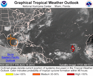
Courtesy of http://www.nhc.noaa.gov/gtwo_atl.shtml
  • Tropical Depression 5 became Tropical Storm Erin out in the eastern Atlantic. The storm is expected to trek west across the Atlantic in the next 5 days. No threat to land in the near future.
  • The tropical wave (Invest 92L) spinning in the Yucatan Peninsula has lost its circulation last night. But with moderate shear and hot water temperatures, we should start to see 92L slowly organizing. Due to the fact it is moving over the peninsula, we will have to wait until it returns back to water for future development. NHC gives it a 50/50 chance of it developing in the next 48 hours.

NATIONAL WEATHER

  • Beautiful weather for the Northeast. Can't ask for anything more. :)
  • Downpours and storms continue to plague the Southeast. Very humid and soupy conditions.
  • Pleasant weather in the Missouri Valley points east. Some afternoon thunderstorms, though, west of there in the Plains with strong to severe potential in western Kansas and western Oklahoma.
  • Dry and seasonable weather for the West Coast and the Rocky Mountains region. Hot in the Pacific Northwest. Cooler along the coast of Washington and Oregon with shower potential from onshore flow from coastal low in the Pacific.

WORLD WEATHER

  • What is left of Utor continues to be a big rainmaker for Southeast China and Northern Vietnam capable of flash flooding and landslides. Utor is blamed for 1 death in China and 8 deaths in the Philippines. The storm has also sunk ships along the Chinese coastline.
  • Mainly quiet and seasonable weather for Europe with showers and isolated thunderstorm chances inland. Dry weather won't last for long as a low pressure in the Northern Atlantic with associated cold front arrives on Friday/Saturday
  • Gusty showers for parts of Southern Australia from a cold front. Dry for the rest of the continent.

EARTHQUAKES

  • There were no earthquakes rated at or above M6 yesterday or so far today.

SPACE WEATHER

Courtesy of spaceweather.com
  • Minor geomagnetic instability yesterday with Kp index reaching 4 last night for a brief time.
  • Magnetic fields on Sunspots 1817 and 1818 have decayed but still a threat for M-class flares. NOAA puts the probabilities of an M-class flare in the next 24 hours at 30%.
  • Solar wind from a coronal hole is now projected to arrive during the weekend.

Wednesday, August 14, 2013

8/14/2013 Daily Update: Drier Second Half of Week, Utor Arrives in China

Good morning everyone!

Showers and storms have cleared the area and our prize is a beautiful, dry second half of the work week. In fact, no rain chances are in sight between now and Sunday. A delightful stretch on the way!

TODAY: Mostly sunny with lower humidity expected. Highs in the low to mid 70s. Breezy with NW winds 10-20 mph, could gust up to 30 mph.

TONIGHT: Mostly clear conditions with lows in the upper 40s to lower 50s. Patchy fog is possible. Winds dying down overnight.

TOMORROW: Sunny with highs between lower 70s in the Berkshires to upper 70s in the Pioneer Valley. Winds from the W at 5 to 10 mph.

NATIONAL WEATHER

  • Turning less humid across the Northeast. High pressure leading to pleasant weather and plenty of sunshine for the region.
  • Soaking thunderstorms remains in the forecast for the Southeast and Gulf States due to a stubborn stalled front.
  • Sunny in the West Coast. Hot and dry in the deserts of the Southwest, cooler along the coastlines.
  • Thunderstorm chances for the Plains up to Montana, Idaho, and Wyoming along the convergence.
  • A ridge in the jet stream builds in the Pacific Northwest allowing hotter air into the area. Showers for the NW Washington tonight from a coastal low advancing into Vancouver.
  • The tropical wave is disorganized but starting to taking shape south of Cuba. Gulf Coast states should continue to watch in the coming days.

WORLD WEATHER

  • Typhoon Utor out in the Western Pacific made landfall in Guangdong Province in Southeast China last night. Death toll in the Philippines has risen to 7.
  • A tropical wave off the coast of Africa is organizing well. NHC gives it a 40% chance of developing in the next 48 hours.
  • Sunny and dry for most of Europe. Chance of showers and storms in the northern part of the continent.
  • Showers and damp weather for Southern Australia, particular in the southeast corner (South Australia, Victoria, Tasmania). Mostly dry for the rest of Australia.

EARTHQUAKES


SPACE WEATHER

  • There were a few C-flares yesterday.
  • Sunspots 1817 and 1818 poses a continued threat for M-class and X-class solar flares. NOAA forecasters are estimating a 30% chance of M-class flares and a 5% chance of X-class flares today. 
  • A solar wind stream from a coronal hole should reach Earth on August 16-18.
  • Kp Index reached 4 for a brief time.
Courtesy of spaceweather.com

Tuesday, August 13, 2013

8/13/2013 Daily Update: Rainy and Stormy Tuesday, Utor Eyes China

Good morning everyone!

High pressure moves offshore and a cold front from the Great Lakes will move in here during the afternoon and evening hours. Showers and storms ahead of the front poses a threat for flooding in the heaviest downpours. Due to a strong jet and modest wind shear values, an isolated severe storm is possible. Though with insufficient instability and heating, a more scattered to widespread threat is not expected. Flooding is the main issue with this storm system.

TODAY: Showers and thunderstorms likely. Humid with dewpoints near 70. Highs to the mid to upper 70s. Winds from the SW at 5 to 10 mph.

TONIGHT: Lingering showers and storms early then clearing out after midnight. Patchy fog developing. Lows in the mid 50s. Winds turning from SW to NW at 5 to 10 mph.

TOMORROW: Beautiful day. Mostly sunny with highs in the lower to mid 70s. Winds from the NW at 5 to 15 mph.

After Tuesday's rain, indications are the rest of the week is dry and seasonable.

NATIONAL WEATHER

  • Showers and thunderstorms in the Northeast and Mid-Atlantic. A few could be strong to severe.
  • Downpours and storms continue for the Midwest, Gulf Coast, and Southeastern states
  • Isolated thunderstorms in the Southwest
  • Dry and sunny in the Upper Midwest
  • Hotter weather as ridge builds in the Pacific Northwest
  • There's an area of interest in the Caribbean that models are developing into a tropical cyclone by the end of the week. Interests in Gulf should monitor.

WORLD WEATHER

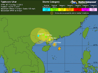
  • Typhoon Utor remains a serious threat for China, now rated Category 2 with winds at 110 mph in the South China Sea. It looks to make landfall southwest of Hong Kong:
Typhoon Udor's projected track. Projected to make landfall in
China tomorrow evening around 9PM EDT.
  • Utor has been blamed for at least 4 deaths in the northern Philippines.
  • Gorgeous weather for the most part in Europe. Scattered storms in the central part of the continent.
  • Dry conditions in North Australia while cold front with associated trough brings showers in the southern region.

EARTHQUAKES

There were no earthquakes rated at or above M6 yesterday or so far today.

SPACE WEATHER

Sunspots 1817 and 1818 poses a threat for M-class and X-class solar flares. NOAA forecasters are estimating a 30% chance of M-class flares and a 5% chance of X-class flares today. A solar wind stream from a coronal hole should reach Earth on August 15-16.

Courtesy of http://www.spaceweather.com

Monday, August 12, 2013

8/12/2013 Daily Update: Unsettled Tonight into Tuesday, Utor Hits Philippines, 3 M6+ Quakes, M-class Flare

Good afternoon everyone!

After a perfect weekend weather-wise, things are starting to get unsettled as we head into the start of the week.

TODAY: Sunny start to the day then clouds move in along with shower chances in the evening. Humidity will be steadily on the rise throughout the day. Highs in the lower to mid 80s. Light southerly wind.

TONIGHT: Showers with possible thunderstorms late tonight into the morning hours, gradually increasing in coverage heading into the afternoon. More humid. Mostly cloudy, with lows in the lower to mid 60s. Winds from the S at 5 to 10 mph.

TOMORROW: Showers and storms are likely, a few could be strong to severe. Fairly widespread rain but most of it ends in the evening with a few lingering showers and storms possible heading into tomorrow night. Outdoor plans are not advised during the afternoon. Mostly cloudy, with highs in the mid to upper 70s. Winds from the SW at 5 to 10 mph.

NATIONAL WEATHER

  • Southwest flow from upper level low in Canada sparking scattered thunderstorms in the Upper Midwest, Northeast, and Mid-Atlantic
  • Thunderstorms in the Gulf Coast and the Midwest, some could turn severe across Northern Oklahoma, Nebraska, Missouri, and Arkansas
  • Sea breeze and comfortable weather for the West Coast. Isolated showers/storms in the Pacific Northwest
  • Chances of thunderstorms continue in the Southeast along the stalled front and battle zone between moist and cooler air
Keeping a close eye on the tropics. There are indications of a storm developing in the Gulf waters late this week.

WORLD WEATHER

  • Typhoon Utor made landfall in the Philippines as a strong Category 4 storm bringing heavy rains, flooding, and landslide threats. At least one death has been blamed on Utor, certainly the number will rise as the country cleans up. China is on alert as Utor is expected to track southwest of Hong Kong as a weakening typhoon. Now at Category 2 with winds at 95 mph.
  • Henriette is no more in the Central Pacific.
  • Calm weather for Europe except for some isolated storms in northern parts. Seasonable temps for many areas, hotter across Spain.
  • A trough is bringing showers and storms to Southern Australia. Warm northwesterlies are bringing a few showers across Southwest Australia. High pressure dominates and keeping most of the continent clear.

EARTHQUAKES

What a way to end the quiet streak! 3 earthquakes greater than or equal to M6 were measured yesterday by the USGS.

M6.0 off the coast of Eastern Indonesia: http://earthquake.usgs.gov/earthquakes/eventpage/usb000j0vl#summary

M6.0 in the northern coast of New Zealand: http://earthquake.usgs.gov/earthquakes/eventpage/usb000j0yl#summary

M6.1 off the coast of NW Peru: http://earthquake.usgs.gov/earthquakes/eventpage/usb000j10u#summary

SPACE WEATHER

Just like the earthquakes, solar activity has begun to pick up. Several C-flares erupted from Sunspot 1817 yesterday and a M1.5-class solar flare this morning that may have hurled a coronal mass ejection at Earth. Sunspots 1817 and 1818 are being monitored for a growing threat of M-class solar flares:


Note: There were no signs of a CME impact yesterday. Either it may have been too weak to register or it missed Earth.

Sunday, August 11, 2013

8/11/2013 Daily Update: Sunny Sunday, Super Typhoon Utor, Perseids, CME Impact

Good afternoon everyone!

Yesterday was a gorgeous day that featured abundant sunshine and a refreshing breeze from the NW. Today is going to be similar, ending the weekend in a sunny note

TODAY: Sunny with highs in the mid 70s to low 80s. Generally calm to light winds blowing from the NW turning around to the W in the afternoon.

TONIGHT: Few clouds move in overnight, lows in the low to mid 50s. Light winds expected.

TOMORROW: Partly cloudy with highs in the upper 70s to low 80s. Humidity is on the rise. There is a slight chance of a shower or storm in the evening hours.

Monitoring an approaching cold front set to arrive Tuesday that will bring chances for storms, potentially strong/severe, and flooding issues again.

NATIONAL WEATHER


  • Thunderstorms continue in the Tennessee Valley and Virginia along the stalled front will bring another round of flooding downpours.
  • Tropical downpours for the Gulf States and the Southeast tapping into the tropical moisture in the Gulf associated with upper level low.
  • Thunderstorms in the Mountain West and Midwest with wider coverage occurring in the afternoon.
  • Low pressure off the coast of the Pacific Northwest will bring showers and thunderstorms to the region in the afternoon.

WORLD WEATHER


  • Super Typhoon Utor in the Western Pacific has reached Category 4 status (winds at 150 mph with gusts up to 185 mph) and will make landfall as a strong/major typhoon in the Philippines by Monday morning. I hope locals are prepping and ready for tremendous winds and flooding that is about to occur.
  • Henriette is now a Tropical Depression and struggling along in the Central Pacific. She's near the end of her life.
  • Cooler air arrives in Europe putting a halt to the heat and relatively dry conditions except for convergence storms in Northeast Europe.
  • Few showers in Southern Australia along a front. Sunny across the interior and east.

EARTHQUAKES


No earthquakes at or above M6 yesterday or so far today. In fact, no earthquakes GREATER than M5.0 since Thursday morning. Very quiet. This makes it 16 days in a row without a earthquake greater or equal to M6.

SPACE WEATHER


  • Tonight is going to be a decent night for viewing the Perseid meteor shower which is at its peak. They will appear in the northeast sky. It is best to view them away from outdoor lights in a dark place.
  • Waiting for a CME that is expected to hit Earth's magnetic field today. Auroras are possible near the poles.
  • A large coronal hole is emerging over the sun's NE limb. Increased solar wind by the second half of the week.

Saturday, August 10, 2013

8/10/2013 Daily Update: Yesterday's Flooding Gone, Beautiful Weekend, CME Impacts Today/Tomorrow

Good morning everyone!

This is the first of many daily updates to come.

Heavy rain from yesterday prompted the NWS to issue Flash Flood Warnings for most of the region. More than 3" of rain fell causing street flooding to occur in the lower Pioneer Valley. Here's the map of rainfall totals from yesterday:


The good news is the cold front has finally cleared making for a gorgeous weekend for outdoor plans.

TODAY: Mostly sunny with highs in the upper 70s to mid 80s. A bit breezy with gusts from the NW over 20 mph.

TONIGHT: Clear with lows in the lower to mid 50s. NW winds diminishing and calming after midnight.

TOMORROW: Sunny with highs in the upper 70s to low 80s. Winds will be out of the W 5-10 mph.

NATIONAL WEATHER

Thunderstorms in the South and Southeast
Thunderstorms across the Mountain West and the upper Midwest
Thunderstorms in the Pacific Northwest

WORLD WEATHER

Tropical Storm Henriette in the Central Pacific is weakening and heading south of Hawaii.
Typhoon Utor in the Western Pacific is on path to make landfall in the Philippines as a strong/major typhoon after the weekend.
Thunderstorms in Central Europe, hot across southern parts
High pressure and mostly dry weather remains firm in Australia. Showers in Tasmania and Western Australia

EARTHQUAKES

No earthquakes at or above M6 yesterday or so far today. This makes it 15 days in a row without a earthquake greater or equal to M6.

SPACE WEATHER

One or two CMEs are expected to hit Earth's magnetic field today or tomorrow. Auroras are possible near the poles.
A large coronal hole is emerging over the sun's NE limb.

Friday, August 9, 2013

Big Plans Ahead!

Hi all,

In my quest to revive the blog again, I am changing things up and adding many new features. Starting tomorrow, I will be posting daily updates that will include the following:

  • Today's local forecast for Western Massachusetts, tonight's and tomorrow's
  • A look at weather around the nation today
  • A look at weather around the world today
  • A list of earthquakes M6 or above from yesterday up to today
  • What's going on in space weather

In addition to these daily updates, expect posts on the weather here locally when bad weather is in the offing and significant weather developments around the world, earthquakes, and space weather as deemed necessary. Also, I plan on doing the following:

  • A weather and climate summary each month for Western MA
  • Live "tweet blog" during significant snowstorms, severe weather outbreaks, tropical cyclones, etc. impacting the region
  • Frequently updated snowfall totals in Southern New England starting October (can't wait!)
  • My own hurricane outlook for next season (maybe?)
  • Expanding the climate data page
  • Top weather events and recap of the year
  • And other miscellaneous goodies... ;)

There's a lot I want to do to make my blog accessible and useful for my diligent followers. I hope I can make it happen through your support. Overall, I want this site to be the best it can be and a one-stop source for weather news and beyond. I am looking forward to the challenge. Thank you for reading and have a nice day!