Thursday, October 3, 2013

10/3/2013 Daily Update: Another Fine Day, Invest 97L on Verge of Becoming Karen

Good morning everyone!

Another fine one today but it starts getting unsettled this weekend with chances of showers culminating into a soaker from a cold front by the start of next week.

TODAY: Mostly sunny with highs in the mid to upper 70s. Winds from the W at 5 mph.

TONIGHT: Mostly cloudy with lows in the lower 50s. Calm winds expected.

TOMORROW: A slight chance of a shower late otherwise mostly cloudy with highs in the mid to upper 70s. Light winds.


ATLANTIC TROPICS

  • Invest 97L is on the verge of becoming Karen. Water vapor shows good structure and is in a favorable environment for strengthening. The Gulf from Louisiana east needs to monitor. Whether it is named or not, the system is expected to move north and merge with a cold front moving across the Easrern U.S. NHC - 80% chance in the next 48 hours.
  • UPDATE (8:13 AM): Looks certain that 97L will be upgraded to Karen. Advisories in the next few hours.
  • Jerry out in the Central Atlantic going out to sea.
Could be declared Karen soon... (Credit: CIMSS)

NATIONAL WEATHER

  • Warm across the Northeast
  • Storms across the Central Plains
  • Warm and humid with scattered storms in the Southeast
  • Hot in the South and Southwest
  • The Northwest is taking a breather with dry and cool weather.

WORLD WEATHER

  • Fitow is a tropical storm in the Western Pacific, expected to strengthen into a typhoon and hook NW toward China this weekend.
  • Rain and storms for Western Europe
  • High keeping most regions dry in Australia except for a few showers in the northwest

EARTHQUAKES

  • There were no earthquakes rated at or above M6 yesterday or so far today.

SPACE WEATHER

  • The Kp index bounced back up to a 5 and there is a chance for more geomagnetic instability associated with the impacts of the CME from yesterday.
  • New sunspots are appearing on the sun but flaring remains low.
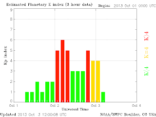
    (Credit: SWPC)

Wednesday, October 2, 2013

10/2/2013 Daily Update: Feels More Like Summer than Autumn, Moderate Solar Storm Impacts, Wild Storms Hit Tasmania

Good morning everyone!

Temperatures are expected to rise into the 80s this afternoon... it will feel more like summer than autumn in New England!

TODAY: Sunny with highs in the upper 70s to lower 80s. Winds from the W at 5 to 10 mph.

TONIGHT: Mostly clear with lows in the upper 40s. Calm winds.

TOMORROW: Mostly sunny with highs in the mid 70s. Winds from the SW at 5 mph.

Rain showers arrive Friday into Saturday and put a brief halt at the extended dry spell we've had. More rain opportunities early next week.


ATLANTIC TROPICS

  • Jerry is out in the central Atlantic and is fairly stationary but will trek east in the next few days with no impacts to land. Jerry's remnants could impact Europe
  • Eyeing Invest 97L in the Caribbean Sea where it could organize into a tropical system as models are predicting.

NATIONAL WEATHER

  • Warm and dry weather for the Northeast
  • Also warm in the Southeast. Showers and storms impacting the Gulf regions.
  • Showers and storms from a low in Nebraska and the Dakotas
  • The season's first snowstorm of the season is taking shape in the northern Rockies with heavy snow in the higher elevations which adds fuel to a potential severe weather outbreak tomorrow in the Midwest.
  • Heavy rain for the Northwest

WORLD WEATHER

  • Two storms in the Western Pacific: Tropical Storm Sepat is impacting the outer Japanese coastline but no direct hit with the storm moving NE away from Japan.
  • Tropical Storm Fitow, however, could mean business with strengthening to a typhoon likely but good news is still days away from any impacts.
  • Rain and storms for parts of the U.K. and Western Europe
  • Severe storms impacted Tasmania yesterday and knocked out power for thousands of people. Finally gets a break with the low moving away and a high replacing it. http://www.theguardian.com/world/2013/oct/02/wild-storms-lash-north-tasmania
Sepat moving away from Japan (Credit: Wunderground)
Extreme weather hits Tassie (Credit: RSOE)

EARTHQUAKES

  • There were no earthquakes rated at or above M6 yesterday or so far today. However, a strong 5.8 hit the Owen Fracture Zone region, further destabilizing the region around the major 7.7 Pakistanian earthquake last week. http://earthquake.usgs.gov/earthquakes/eventpage/usb000k49t#summary
  • NOTE: Since the government shutdown may disrupt the timeliness of the USGS feed, I may have to resort to other sources for earthquake info.

SPACE WEATHER

  • A CME buffeted Earth's magnetosphere last night, sparking a moderate G2 level geomagnetic storm and brought a dazzling display of auroras across Canada and the northern U.S. The solar wind speed took a huge leap from 300 km/s to over 600 km/s a little past 01 UTC signaling the arrival of the CME. The Kp index peaked at 6 which is moderate on the scale. 
  • The arrival came earlier than expected from the magnetic filament that erupted from the sun Sunday night. Imagine a weather forecast being off by 1 or 2 days? Yeah, space weather forecasting is definitely at its infancy. Suppose if the CME came a little faster, then disruptions in satellites or even power grids are a possibility. A long way to go in learning about our sun. The solar storm looks to be subsiding but strong solar winds could cause additional minor storms.
  • New sunspots are appearing on the sun's eastern limb. Sunspot 1855 is growing but none posing a strong threat for an M-class flare.
A sharp bump in the solar wind on the ACE (Credit: SWPC)

Tuesday, October 1, 2013

The 1st Annual 2013-14 SNE Snowfall Contest!

Welcome to the first annual SNE Snowfall Contest! Partly because of the Golden Snow Globe, I've decided to make my own fun contest for Southern New England and see which city or town comes out on top and takes the SNE crown! In preparation, I've complied a large list of 175 stations located in Massachusetts, Connecticut, and Rhode Island and plan on collecting seasonal snowfall data from various sources such as NWS, iembot, Accuweather, CoCoRaHS, and also through viewers as well! (Mention me on Twitter if you want your location to be added.) Seasonal snowfall are going to be updated frequently. The season runs from the first snowfall to the last. Every tenth of an inch of snow counts! The following details how this contest runs:


TITLES


Besides the top prize for the town with the highest snowfall, there will be separate "titles" to compete for: highest snowfall from each state (Massachusetts, Connecticut, and Rhode Island), highest snowfall in Western MA, and highest snowfall from the five primary climo stations in SNE (BOS, ORH, BDL, PVD, and BDR). Up-to-date standings can be seen on the left side of the site.

Miscellaneous stats such as the location with the highest daily snowfall for the whole season or the highest snowfall for each month will be recognized on the first day of the month of each daily update. After the last snowfall and season ends, a complete summary of everything will be made available.


GUIDELINES

  • The list is not final by any means and probably will never be! New stations will be added as I encounter them. Also, stations that don't consistently report back snowfall totals are subject for removal by my discretion.
  • All data will be quality checked for accuracy. I don't want bad numbers!
  • You may notice some locations have multiple stations. In finding out which town places where, the HIGHEST total is counted in the results. No chance of say, Falmouth, sweeping the top 6 positions lol.
  • I plan on sharing the spreadsheets I use to enter data once I add in all 175 cities so everyone can look back at past daily totals. I will have them up by this weekend and they will be included in this post. Check back later!


THE LIST AND MAP


Here's the list and map of the 175 cities and towns used to tabulated the results. They are ever-changing and will be constantly updated. A spreadsheet with up-to-date totals will be added once I add in every city.

(MAP KEY: Orange - CoCoRaHS stations, Blue - COOP stations, Red - ASOS stations, Green - User-contributed)


CONCLUSION


I'm sure I'm not the only one excited for the upcoming winter. Looking forward to crunching the data! Good luck contestants and may the snow be with you!

P.S. Rooting for Amherst! ;)

10/1/2013 Daily Update: Turning Hotter Today, Tornado Hits Near Seattle, Jerry Forms in the Central Atlantic

Good morning everyone!

Today is the first day of October and we are turning on the heat for Tuesday and Wednesday with temperatures around or above 80 degrees both days.

TODAY: Sunny with highs around 80. Winds from the NW at 5 mph.

TONIGHT: Mostly clear with lows in the upper 40s to lower 50s. Winds generally calm.

TOMORROW: Sunny with highs in the upper 70s to lower 80s. Winds from the NW at 5 to 15 mph.

A little bump in the road with rain showers possible Friday afternoon to Friday evening with a weak disturbance moving through. Then potentially a greater threat of rain after this weekend... we will see.

NOTE: A post about the 1st annual SNE snowfall contest will be released later this afternoon or evening. It will cover specifications and present a list of cities along with a map plotted!


ATLANTIC TROPICS

  • Tropical Storm Jerry becomes the 10th named storm of the season in the Central Atlantic. Jerry should remain weak with no impacts to land expected.
  • Monitoring the slow progression of Invest 97L. The low moves into the Gulf this weekend where it will have a chance at strengthening into a tropical storm.

NATIONAL WEATHER


WORLD WEATHER

  • Wutip left at least 5 dead and dozens missing after making landfall in Vietnam. http://news.yahoo.com/75-missing-boats-sink-south-china-sea-typhoon-051207452.html
  • Sepat SE of Japan is making a glancing swipe at Japan
  • Tropical Storm Fitow forms to the east of the Phillippines and gradual strengthening expected.
  • High pressure north keeping things dry with two distinct lows producing storms in southern Europe
  • A front crossing SE Australia is bringing showers and storms to Queensland, New South Wales, Victoria, and Tasmania. Otherwise, high pressure keeping other regions dry.

EARTHQUAKES


SPACE WEATHER

  • Low activity continues though Sunspot 1855 is starting to expand and could be a threat for C-class to M-class flares going forward if development continues. Other sunspots not so impressive. The CME from Sunday evening is expected to impact Earth's geomagnetic field within the next two days as a glancing blow. Threats are auroras in the polar regions and a chance at minor satellite disruptions.