Friday, August 16, 2013

8/16/2013 Daily Update: Splendid Friday, 6.5 Earthquake Hits New Zealand

Good morning everyone!

We continue our streak of beautiful days marked by comfortable temperatures and dry conditions with plenty of sunshine.

TODAY: Mostly sunny with highs in the mid to upper 70s in the Berkshires to low 80s in the valley. Winds from the W at 5 to 10 mph.

TONIGHT: Mostly clear with lows in the lower 50s. Light winds.

TOMORROW: Mostly sunny with highs in the upper 70s to mid 80s. Generally light winds from the west.

The 90s could return as early as next week. Be ready!

ATLANTIC TROPICS
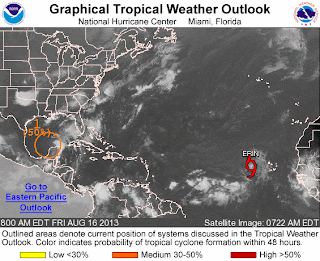
Courtesy of http://www.nhc.noaa.gov/gtwo_atl.shtml
  • Tropical Storm Erin meanders in the Atlantic with no threats to land in the foreseeable future. Should see her turn more toward the NW which indications are she'll likely be a fish storm.
  • Invest 92L is trying to organize in the Yucatan Peninsula. There's a good chance today of it strengthening now that it's moving over the Gulf of Mexico and with lessening shear. NHC gives Invest 92L a 50% chance of developing in the next 48 hours.

NATIONAL WEATHER

  • Gorgeous weather for the Northeast again.
  • Wash, rinse, repeat: Showers and thunderstorms for the Southeast.
  • Isolated thunderstorms in Texas
  • Hot inland and dry in the Southwest and the West Coast. Few showers in NW Washington.

WORLD WEATHER

  • Remnants of Utor brings heavy rains and flooding potential for Southeast China and Northern Vietnam.
  • A tropical wave SW of Hawaii in the Central Pacific is on the verge of becoming a tropical cyclone. Since it's about to cross over the International Date Line, the JMA will take over.
  • Showers and storms for the United Kingdom as a cold front arrives in Europe. Generally dry conditions elsewhere.
  • Same story with fronts crossing Southern Australia producing showers and storms there. Sunny and dry in the rest of Australia.

EARTHQUAKES


SPACE WEATHER

  • A high solar wind stream is producing a minor geomagnetic storm. The Kp-index rose to 5 last night and solar wind speeds are over 700 km/sec. Normal would be around 300 km/sec.
  • None of the sunspots are actively flaring but still magnetically capable of producing M-class flares. NOAA forecasters put chances at 35% for a M-class flare in the next 24 hours. A sunspot on the eastern limb of the sun is turning toward the Earth.

Thursday, August 15, 2013

8/15/2013 Daily Update: Pleasant Thursday, Tropical Storm Erin

Good afternoon everyone!

After a cool start to the day, it's going to be another pleasant one. Beautiful weather for your Thursday and it will stay that way for the next several days.

TODAY: Sunny, with highs in the mid to upper 70s. Winds from the W at 5 to 10 mph.

TONIGHT: Mostly clear skies with lows in the upper 40s to lower 50s. Generally calm winds.

TOMORROW: Sunny, with highs in the mid 70s to near 80 degrees. Winds from the W at 5 to 10 mph.

Quiet weather lasts into Sunday. Signs of heat in the forecast for next week.

ATLANTIC TROPICS

Courtesy of http://www.nhc.noaa.gov/gtwo_atl.shtml
  • Tropical Depression 5 became Tropical Storm Erin out in the eastern Atlantic. The storm is expected to trek west across the Atlantic in the next 5 days. No threat to land in the near future.
  • The tropical wave (Invest 92L) spinning in the Yucatan Peninsula has lost its circulation last night. But with moderate shear and hot water temperatures, we should start to see 92L slowly organizing. Due to the fact it is moving over the peninsula, we will have to wait until it returns back to water for future development. NHC gives it a 50/50 chance of it developing in the next 48 hours.

NATIONAL WEATHER

  • Beautiful weather for the Northeast. Can't ask for anything more. :)
  • Downpours and storms continue to plague the Southeast. Very humid and soupy conditions.
  • Pleasant weather in the Missouri Valley points east. Some afternoon thunderstorms, though, west of there in the Plains with strong to severe potential in western Kansas and western Oklahoma.
  • Dry and seasonable weather for the West Coast and the Rocky Mountains region. Hot in the Pacific Northwest. Cooler along the coast of Washington and Oregon with shower potential from onshore flow from coastal low in the Pacific.

WORLD WEATHER

  • What is left of Utor continues to be a big rainmaker for Southeast China and Northern Vietnam capable of flash flooding and landslides. Utor is blamed for 1 death in China and 8 deaths in the Philippines. The storm has also sunk ships along the Chinese coastline.
  • Mainly quiet and seasonable weather for Europe with showers and isolated thunderstorm chances inland. Dry weather won't last for long as a low pressure in the Northern Atlantic with associated cold front arrives on Friday/Saturday
  • Gusty showers for parts of Southern Australia from a cold front. Dry for the rest of the continent.

EARTHQUAKES

  • There were no earthquakes rated at or above M6 yesterday or so far today.

SPACE WEATHER

Courtesy of spaceweather.com
  • Minor geomagnetic instability yesterday with Kp index reaching 4 last night for a brief time.
  • Magnetic fields on Sunspots 1817 and 1818 have decayed but still a threat for M-class flares. NOAA puts the probabilities of an M-class flare in the next 24 hours at 30%.
  • Solar wind from a coronal hole is now projected to arrive during the weekend.

Wednesday, August 14, 2013

8/14/2013 Daily Update: Drier Second Half of Week, Utor Arrives in China

Good morning everyone!

Showers and storms have cleared the area and our prize is a beautiful, dry second half of the work week. In fact, no rain chances are in sight between now and Sunday. A delightful stretch on the way!

TODAY: Mostly sunny with lower humidity expected. Highs in the low to mid 70s. Breezy with NW winds 10-20 mph, could gust up to 30 mph.

TONIGHT: Mostly clear conditions with lows in the upper 40s to lower 50s. Patchy fog is possible. Winds dying down overnight.

TOMORROW: Sunny with highs between lower 70s in the Berkshires to upper 70s in the Pioneer Valley. Winds from the W at 5 to 10 mph.

NATIONAL WEATHER

  • Turning less humid across the Northeast. High pressure leading to pleasant weather and plenty of sunshine for the region.
  • Soaking thunderstorms remains in the forecast for the Southeast and Gulf States due to a stubborn stalled front.
  • Sunny in the West Coast. Hot and dry in the deserts of the Southwest, cooler along the coastlines.
  • Thunderstorm chances for the Plains up to Montana, Idaho, and Wyoming along the convergence.
  • A ridge in the jet stream builds in the Pacific Northwest allowing hotter air into the area. Showers for the NW Washington tonight from a coastal low advancing into Vancouver.
  • The tropical wave is disorganized but starting to taking shape south of Cuba. Gulf Coast states should continue to watch in the coming days.

WORLD WEATHER

  • Typhoon Utor out in the Western Pacific made landfall in Guangdong Province in Southeast China last night. Death toll in the Philippines has risen to 7.
  • A tropical wave off the coast of Africa is organizing well. NHC gives it a 40% chance of developing in the next 48 hours.
  • Sunny and dry for most of Europe. Chance of showers and storms in the northern part of the continent.
  • Showers and damp weather for Southern Australia, particular in the southeast corner (South Australia, Victoria, Tasmania). Mostly dry for the rest of Australia.

EARTHQUAKES


SPACE WEATHER

  • There were a few C-flares yesterday.
  • Sunspots 1817 and 1818 poses a continued threat for M-class and X-class solar flares. NOAA forecasters are estimating a 30% chance of M-class flares and a 5% chance of X-class flares today. 
  • A solar wind stream from a coronal hole should reach Earth on August 16-18.
  • Kp Index reached 4 for a brief time.
Courtesy of spaceweather.com

Tuesday, August 13, 2013

8/13/2013 Daily Update: Rainy and Stormy Tuesday, Utor Eyes China

Good morning everyone!

High pressure moves offshore and a cold front from the Great Lakes will move in here during the afternoon and evening hours. Showers and storms ahead of the front poses a threat for flooding in the heaviest downpours. Due to a strong jet and modest wind shear values, an isolated severe storm is possible. Though with insufficient instability and heating, a more scattered to widespread threat is not expected. Flooding is the main issue with this storm system.

TODAY: Showers and thunderstorms likely. Humid with dewpoints near 70. Highs to the mid to upper 70s. Winds from the SW at 5 to 10 mph.

TONIGHT: Lingering showers and storms early then clearing out after midnight. Patchy fog developing. Lows in the mid 50s. Winds turning from SW to NW at 5 to 10 mph.

TOMORROW: Beautiful day. Mostly sunny with highs in the lower to mid 70s. Winds from the NW at 5 to 15 mph.

After Tuesday's rain, indications are the rest of the week is dry and seasonable.

NATIONAL WEATHER

  • Showers and thunderstorms in the Northeast and Mid-Atlantic. A few could be strong to severe.
  • Downpours and storms continue for the Midwest, Gulf Coast, and Southeastern states
  • Isolated thunderstorms in the Southwest
  • Dry and sunny in the Upper Midwest
  • Hotter weather as ridge builds in the Pacific Northwest
  • There's an area of interest in the Caribbean that models are developing into a tropical cyclone by the end of the week. Interests in Gulf should monitor.

WORLD WEATHER

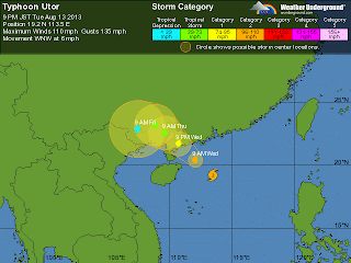
  • Typhoon Utor remains a serious threat for China, now rated Category 2 with winds at 110 mph in the South China Sea. It looks to make landfall southwest of Hong Kong:
Typhoon Udor's projected track. Projected to make landfall in
China tomorrow evening around 9PM EDT.
  • Utor has been blamed for at least 4 deaths in the northern Philippines.
  • Gorgeous weather for the most part in Europe. Scattered storms in the central part of the continent.
  • Dry conditions in North Australia while cold front with associated trough brings showers in the southern region.

EARTHQUAKES

There were no earthquakes rated at or above M6 yesterday or so far today.

SPACE WEATHER

Sunspots 1817 and 1818 poses a threat for M-class and X-class solar flares. NOAA forecasters are estimating a 30% chance of M-class flares and a 5% chance of X-class flares today. A solar wind stream from a coronal hole should reach Earth on August 15-16.

Courtesy of http://www.spaceweather.com