Wednesday, August 14, 2013

8/14/2013 Daily Update: Drier Second Half of Week, Utor Arrives in China

Good morning everyone!

Showers and storms have cleared the area and our prize is a beautiful, dry second half of the work week. In fact, no rain chances are in sight between now and Sunday. A delightful stretch on the way!

TODAY: Mostly sunny with lower humidity expected. Highs in the low to mid 70s. Breezy with NW winds 10-20 mph, could gust up to 30 mph.

TONIGHT: Mostly clear conditions with lows in the upper 40s to lower 50s. Patchy fog is possible. Winds dying down overnight.

TOMORROW: Sunny with highs between lower 70s in the Berkshires to upper 70s in the Pioneer Valley. Winds from the W at 5 to 10 mph.

NATIONAL WEATHER

  • Turning less humid across the Northeast. High pressure leading to pleasant weather and plenty of sunshine for the region.
  • Soaking thunderstorms remains in the forecast for the Southeast and Gulf States due to a stubborn stalled front.
  • Sunny in the West Coast. Hot and dry in the deserts of the Southwest, cooler along the coastlines.
  • Thunderstorm chances for the Plains up to Montana, Idaho, and Wyoming along the convergence.
  • A ridge in the jet stream builds in the Pacific Northwest allowing hotter air into the area. Showers for the NW Washington tonight from a coastal low advancing into Vancouver.
  • The tropical wave is disorganized but starting to taking shape south of Cuba. Gulf Coast states should continue to watch in the coming days.

WORLD WEATHER

  • Typhoon Utor out in the Western Pacific made landfall in Guangdong Province in Southeast China last night. Death toll in the Philippines has risen to 7.
  • A tropical wave off the coast of Africa is organizing well. NHC gives it a 40% chance of developing in the next 48 hours.
  • Sunny and dry for most of Europe. Chance of showers and storms in the northern part of the continent.
  • Showers and damp weather for Southern Australia, particular in the southeast corner (South Australia, Victoria, Tasmania). Mostly dry for the rest of Australia.

EARTHQUAKES


SPACE WEATHER

  • There were a few C-flares yesterday.
  • Sunspots 1817 and 1818 poses a continued threat for M-class and X-class solar flares. NOAA forecasters are estimating a 30% chance of M-class flares and a 5% chance of X-class flares today. 
  • A solar wind stream from a coronal hole should reach Earth on August 16-18.
  • Kp Index reached 4 for a brief time.
Courtesy of spaceweather.com

Tuesday, August 13, 2013

8/13/2013 Daily Update: Rainy and Stormy Tuesday, Utor Eyes China

Good morning everyone!

High pressure moves offshore and a cold front from the Great Lakes will move in here during the afternoon and evening hours. Showers and storms ahead of the front poses a threat for flooding in the heaviest downpours. Due to a strong jet and modest wind shear values, an isolated severe storm is possible. Though with insufficient instability and heating, a more scattered to widespread threat is not expected. Flooding is the main issue with this storm system.

TODAY: Showers and thunderstorms likely. Humid with dewpoints near 70. Highs to the mid to upper 70s. Winds from the SW at 5 to 10 mph.

TONIGHT: Lingering showers and storms early then clearing out after midnight. Patchy fog developing. Lows in the mid 50s. Winds turning from SW to NW at 5 to 10 mph.

TOMORROW: Beautiful day. Mostly sunny with highs in the lower to mid 70s. Winds from the NW at 5 to 15 mph.

After Tuesday's rain, indications are the rest of the week is dry and seasonable.

NATIONAL WEATHER

  • Showers and thunderstorms in the Northeast and Mid-Atlantic. A few could be strong to severe.
  • Downpours and storms continue for the Midwest, Gulf Coast, and Southeastern states
  • Isolated thunderstorms in the Southwest
  • Dry and sunny in the Upper Midwest
  • Hotter weather as ridge builds in the Pacific Northwest
  • There's an area of interest in the Caribbean that models are developing into a tropical cyclone by the end of the week. Interests in Gulf should monitor.

WORLD WEATHER

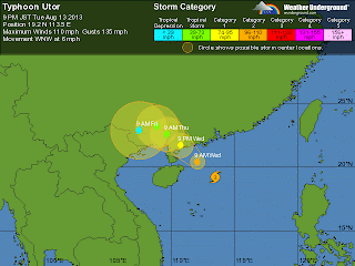
  • Typhoon Utor remains a serious threat for China, now rated Category 2 with winds at 110 mph in the South China Sea. It looks to make landfall southwest of Hong Kong:
Typhoon Udor's projected track. Projected to make landfall in
China tomorrow evening around 9PM EDT.
  • Utor has been blamed for at least 4 deaths in the northern Philippines.
  • Gorgeous weather for the most part in Europe. Scattered storms in the central part of the continent.
  • Dry conditions in North Australia while cold front with associated trough brings showers in the southern region.

EARTHQUAKES

There were no earthquakes rated at or above M6 yesterday or so far today.

SPACE WEATHER

Sunspots 1817 and 1818 poses a threat for M-class and X-class solar flares. NOAA forecasters are estimating a 30% chance of M-class flares and a 5% chance of X-class flares today. A solar wind stream from a coronal hole should reach Earth on August 15-16.

Courtesy of http://www.spaceweather.com

Monday, August 12, 2013

8/12/2013 Daily Update: Unsettled Tonight into Tuesday, Utor Hits Philippines, 3 M6+ Quakes, M-class Flare

Good afternoon everyone!

After a perfect weekend weather-wise, things are starting to get unsettled as we head into the start of the week.

TODAY: Sunny start to the day then clouds move in along with shower chances in the evening. Humidity will be steadily on the rise throughout the day. Highs in the lower to mid 80s. Light southerly wind.

TONIGHT: Showers with possible thunderstorms late tonight into the morning hours, gradually increasing in coverage heading into the afternoon. More humid. Mostly cloudy, with lows in the lower to mid 60s. Winds from the S at 5 to 10 mph.

TOMORROW: Showers and storms are likely, a few could be strong to severe. Fairly widespread rain but most of it ends in the evening with a few lingering showers and storms possible heading into tomorrow night. Outdoor plans are not advised during the afternoon. Mostly cloudy, with highs in the mid to upper 70s. Winds from the SW at 5 to 10 mph.

NATIONAL WEATHER

  • Southwest flow from upper level low in Canada sparking scattered thunderstorms in the Upper Midwest, Northeast, and Mid-Atlantic
  • Thunderstorms in the Gulf Coast and the Midwest, some could turn severe across Northern Oklahoma, Nebraska, Missouri, and Arkansas
  • Sea breeze and comfortable weather for the West Coast. Isolated showers/storms in the Pacific Northwest
  • Chances of thunderstorms continue in the Southeast along the stalled front and battle zone between moist and cooler air
Keeping a close eye on the tropics. There are indications of a storm developing in the Gulf waters late this week.

WORLD WEATHER

  • Typhoon Utor made landfall in the Philippines as a strong Category 4 storm bringing heavy rains, flooding, and landslide threats. At least one death has been blamed on Utor, certainly the number will rise as the country cleans up. China is on alert as Utor is expected to track southwest of Hong Kong as a weakening typhoon. Now at Category 2 with winds at 95 mph.
  • Henriette is no more in the Central Pacific.
  • Calm weather for Europe except for some isolated storms in northern parts. Seasonable temps for many areas, hotter across Spain.
  • A trough is bringing showers and storms to Southern Australia. Warm northwesterlies are bringing a few showers across Southwest Australia. High pressure dominates and keeping most of the continent clear.

EARTHQUAKES

What a way to end the quiet streak! 3 earthquakes greater than or equal to M6 were measured yesterday by the USGS.

M6.0 off the coast of Eastern Indonesia: http://earthquake.usgs.gov/earthquakes/eventpage/usb000j0vl#summary

M6.0 in the northern coast of New Zealand: http://earthquake.usgs.gov/earthquakes/eventpage/usb000j0yl#summary

M6.1 off the coast of NW Peru: http://earthquake.usgs.gov/earthquakes/eventpage/usb000j10u#summary

SPACE WEATHER

Just like the earthquakes, solar activity has begun to pick up. Several C-flares erupted from Sunspot 1817 yesterday and a M1.5-class solar flare this morning that may have hurled a coronal mass ejection at Earth. Sunspots 1817 and 1818 are being monitored for a growing threat of M-class solar flares:


Note: There were no signs of a CME impact yesterday. Either it may have been too weak to register or it missed Earth.

Sunday, August 11, 2013

8/11/2013 Daily Update: Sunny Sunday, Super Typhoon Utor, Perseids, CME Impact

Good afternoon everyone!

Yesterday was a gorgeous day that featured abundant sunshine and a refreshing breeze from the NW. Today is going to be similar, ending the weekend in a sunny note

TODAY: Sunny with highs in the mid 70s to low 80s. Generally calm to light winds blowing from the NW turning around to the W in the afternoon.

TONIGHT: Few clouds move in overnight, lows in the low to mid 50s. Light winds expected.

TOMORROW: Partly cloudy with highs in the upper 70s to low 80s. Humidity is on the rise. There is a slight chance of a shower or storm in the evening hours.

Monitoring an approaching cold front set to arrive Tuesday that will bring chances for storms, potentially strong/severe, and flooding issues again.

NATIONAL WEATHER


  • Thunderstorms continue in the Tennessee Valley and Virginia along the stalled front will bring another round of flooding downpours.
  • Tropical downpours for the Gulf States and the Southeast tapping into the tropical moisture in the Gulf associated with upper level low.
  • Thunderstorms in the Mountain West and Midwest with wider coverage occurring in the afternoon.
  • Low pressure off the coast of the Pacific Northwest will bring showers and thunderstorms to the region in the afternoon.

WORLD WEATHER


  • Super Typhoon Utor in the Western Pacific has reached Category 4 status (winds at 150 mph with gusts up to 185 mph) and will make landfall as a strong/major typhoon in the Philippines by Monday morning. I hope locals are prepping and ready for tremendous winds and flooding that is about to occur.
  • Henriette is now a Tropical Depression and struggling along in the Central Pacific. She's near the end of her life.
  • Cooler air arrives in Europe putting a halt to the heat and relatively dry conditions except for convergence storms in Northeast Europe.
  • Few showers in Southern Australia along a front. Sunny across the interior and east.

EARTHQUAKES


No earthquakes at or above M6 yesterday or so far today. In fact, no earthquakes GREATER than M5.0 since Thursday morning. Very quiet. This makes it 16 days in a row without a earthquake greater or equal to M6.

SPACE WEATHER


  • Tonight is going to be a decent night for viewing the Perseid meteor shower which is at its peak. They will appear in the northeast sky. It is best to view them away from outdoor lights in a dark place.
  • Waiting for a CME that is expected to hit Earth's magnetic field today. Auroras are possible near the poles.
  • A large coronal hole is emerging over the sun's NE limb. Increased solar wind by the second half of the week.