Wednesday, October 9, 2013

10/9/2013 Daily Update: Mostly Sunny Wednesday, CME Impact, M-class Solar Flare

Good morning everyone!

A frosty morning leads to a cool afternoon with temps in the lower 60s. High pressure parked in New England is keeping rain showers south of here.

TODAY: Mostly sunny with highs in the lower 60s. Winds from the NE at 5 to 10 mph.

TONIGHT: Partly cloudy with lows in the lower 40s. Winds from the NE at 5 mph.

TOMORROW: Mostly cloudy with highs in the lower to mid 60s. Winds from the NE at 5 mph.

A few rain showers may creep in from the south late Thursday. Depends on how far north the extent of the rain comes.


ATLANTIC TROPICS

  • Area of low pressure south of the Cape Verde islands is being watched for possible development. It's becoming more organized and according to the NHC, has a 30% chance of developing in the next 48 hours.

NATIONAL WEATHER

  • High pressure keeping things dry in the Northeast
  • Rain showers and wind impacting the Mid-Atlantic from NJ to SC
  • Comfortable temps in the Southeast and Gulf
  • Breezy and warm in the South and Midwest
  • Cooler across the Rockies and Northern Plains
  • Beautiful in the Northwest

WORLD WEATHER

  • A tropical depression formed east of the Phillippines and slated to move west  and strengthen toward the Phillippines by the weekend.
  • A tropical cyclone developed in the Indian Ocean, tracking toward India.
  • Narda in the Eastern Pacific weakens into a tropical depression.
  • Showers and storms associated with the Mediterranean low in Europe
  • A cold front is sweeping through Southeast Australia bringing in cooler air. Hot and gusty NW winds in the interior increasing fire danger.

EARTHQUAKES

  • There were no earthquakes rated at or above M6 yesterday or so far today.

SPACE WEATHER

  • Busy evening yesterday in the space weather department. A CME impacted the Earth's magnetic field causing auroras to be seen as far south as the Northern US. The Kp index rose to a 6 for a brief period of time which is moderate geomagnetic storm conditions. Minor geomagnetic activity remains possible today.
  • A moderate M2-class solar flare erupted from the southeast quadrant of the sun. The solar flare was not directed toward Earth since it wasn't Earth-facing but the active is turning toward our planet. This was the strongest solar flare since August. The flare is believed to come from Sunspots 1864-1865. M-class flare chances are set at 10% in the next 24 hours.
  • Solar wind from an Earth-facing coronal hole is projected to reach Earth in the next 2 or 3 days.
An increasing number of spots turning toward Earth
(Credit: SpaceWeather.com)

Tuesday, October 8, 2013

10/8/2013 Daily Update: Clearing Out After Yesterday's Windstorm, Danas Weakens, Unusual Quake Strikes Off East Coast

Good afternoon everyone!

A powerful cold front worked its way through New England yesterday and there was a good number of wind damage being reported as wind gusts exceeded 30-40 mph. The rain is gone and today is going to be brilliant!

TODAY: Sunny with highs in the mid to upper 60s. Winds from the N at 5 to 10 mph.

TONIGHT: Mostly clear with lows in the lower 40s. Winds generally light.

TOMORROW: Sunny with highs in the mid 60s. Winds from the NE at 5 mph.


ATLANTIC TROPICS

  • A tropical wave south of the Cape Verde islands have a moderate chance of development. Models have been developing this into a tropical system.

NATIONAL WEATHER

  • Seasonable in the Northeast
  • A few showers and storms along the Southeast coast
  • Dry and warm in the central portion of the country
  • Cooler along the Rockies
  • Showers and high elevation snows in the Northwest

WORLD WEATHER

  • Danas has weakened into a tropical storm and will continue to weaken as it moves northeast into Japan. Damaging winds and heavy rainfall are the threats for South Korea and Japan.
  • Narda is a tropical storm in the Eastern Pacific posing no danger to land.
  • A few storms in the Mediterranean otherwise mostly dry for rest of Europe
  • High in eastern Australia is keeping showers south

EARTHQUAKES


SPACE WEATHER

  • A filament erupted and a CME is produced heading toward Earth tomorrow. NOAA forecasters estimate a 30% to 40% chance of polar geomagnetic storms.
  • Flaring remains low with only C-class flares in the last few days. Sunspots aren't posing a threat for strong flares.

Monday, October 7, 2013

10/7/2013 Daily Update: Strong Cold Front Bringing Gusty Showers and Storms Today, Typhoon Danas Rapidly Strengthens

Good morning everyone!

Short update today. Gusty showers and storms this afternoon with association of a strong cold front passage. These winds can pick up suddenly so good idea to keep a close eye on the radar. A brief, isolated spin up can't be ruled out. It's the same system that dropped 3 feet of snow in the Rockies and produced tornadoes in Iowa and Nebraska so it certainly has a history of severe weather. The rain should clear after midnight and tomorrow will be dry and sunny with temps in the 60s.

  • Quiet in the Atlantic
  • Typhoon Fitow has made landfall in eastern China. Flooding is imminent and cautionary measures are being taken with many evacuations.
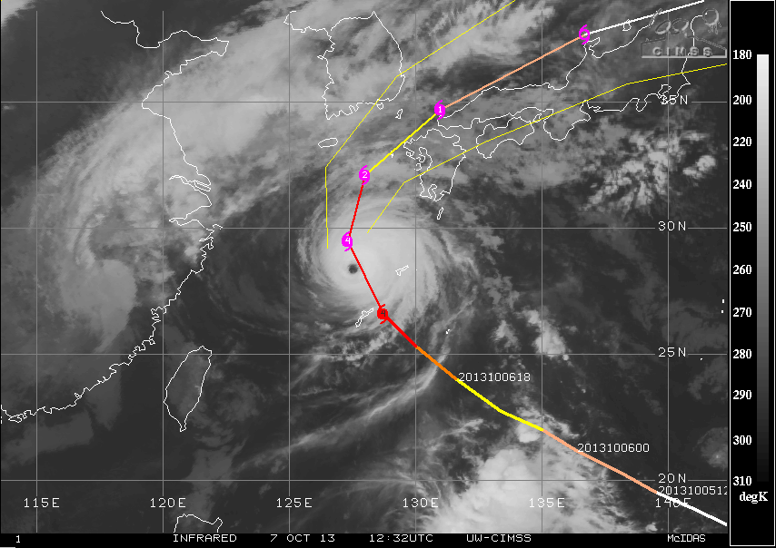
  • Danas nears Super Typhoon status with max winds at 145mph after rapid strengthening yesterday. As was mentioned yesterday, it already had great structure and well-developed eye. It is now a Category 4 and swinging east toward Japan. Going to be long days ahead for them.
Danas is impressive on infrared after strengthening rapidly yesterday
(Credit: CIMSS)
  • Tropical Storm Narda forms in the Eastern Pacific. No land impacts expected.
  • There were no earthquakes rated at or above M6 yesterday or so far today.
  • Sunspot 1856 produced a C-class flare last night. Shall monitor the possibility for stronger flares around that region. M-class flare percentage have bumped up to 10% in the next 24 hours.
Sunspot 1856 is active (Credit: SpaceWeather.com)

Sunday, October 6, 2013

10/6/2013 Daily Update: Dull Sunday, Karen Dissipates, Typhoon Fitow Makes Landfall in Southeast China

Good afternoon everyone!

A dull kind of day today with overcast skies, showers around, and temperatures around 60 degrees with an east wind. Gusty showers and chances of storms are slated for Monday afternoon, some of which could produce heavy rain.

TODAY: Scattered showers with highs in the lower 60s. Winds from the E at 5 mph.

TONIGHT: Scattered showers with lows in the mid 50s. Winds from the E at 5 mph.

TOMORROW: Showers and storms increase in coverage by the afternoon from west to east. Mostly cloudy with highs in the lower to mid 70s. Winds from the S at 5 to 10 mph with gusts as high as 25 mph.


ATLANTIC TROPICS

  • Karen has weakened and dissipated along the Louisiana Gulf Coast. The remnants are affecting the region. Overall though, impacts were far less than what could have been.

NATIONAL WEATHER

  • Cool and showery in New England while south of the stationary front in northern NJ are experiencing warm and humid weather
  • Disorganized line of showers and storms are crossing the Ohio and Tennessee valleys
  • Moisture of former Karen are dumping rain in the Southeast
  • Cooler weather for the Upper Midwest and pleasant conditions in the west

WORLD WEATHER

  • Typhoon Fitow is making landfall in southeast China. Evacuations underway and China has issued a top-level red alert for the storm. Heavy rain, flooding, and landslides are the threats.
  • We have Danas behind Fitow which has strengthened into a Category 2 typhoon and make a run for Super Typhoon as it approaches the Japanese coast.
  • Low pressure system bringing showers and storms for the Italian peninsula. Showers in the U.K. and northern Europe
  • Showers affecting the South Island, New Zealand are gone. Some showers in New South Wales otherwise most of the continent is dry.
Fitow impacts Southeast China today. You can see Typhoon Danas
in the same image on the right side. Quite an impressive eye. (Credit: CIMSS)

EARTHQUAKES


SPACE WEATHER

  • Solar activity is low and flaring is barely existing above the C-class range. Not much else to say. A large coronal hole is turning to face Earth and could increase solar wind speeds in the next several days.