Wednesday, September 4, 2013

9/4/2013 Daily Update: Kicking Out the Humidity & Storms; Earthquakes Shake Canada, Japan, Alaska; Toraji Hits Japan

Good morning everyone!

After a couple days of stormy weather, today is going to be fantastic with sunny skies and lower humidity.

TODAY: Sunny with highs in the upper 70s to lower 80s. Comfortable with lower humidity. Winds from the NW to W at 5 to 10 mph.

TONIGHT: Clouds increasing and a small chance of a shower into the morning hours. Lows in the mid 50s. Winds from the W at 5 mph.

TOMORROW: Chance of showers in the morning. Mostly cloudy to start, sunny by the afternoon. Cooler too with highs only reaching the lower 70s. Winds from the NW at 5 to 15 mph.

Looking ahead... mainly comfortable weather with through the weekend with temperatures in the 70s.


ATLANTIC TROPICS

  • Invest 97L has crossed the Antilles and development is currently being hindered due to close proximity to land though upper-level winds are favorable. NHC is forecasting a 40% chance of developing in the next 48 hours. I agree.
  • A tropical wave in the Yucatan has a small chance of developing. NHC: 20% chance in the next 48 hours.
  • An error from the last daily update - it's the wave behind current one that the GFS forms into a tropical cyclone and potential hurricane around September 11th, the date of the latest forming hurricane. We'll have to see how this shapes up.
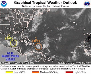
Quiet Atlantic so far...

NATIONAL WEATHER

  • Storms have cleared and warmer for the Northeast and Mid-Atlantic
  • Spotty thunderstorms forecasted for the Southeast and the Gulf Coast
  • Very warm and dry in the Midwest and South
  • Strong to severe thunderstorms may be in store for the interior Pacific Northwest into the northern Intermountain region

WORLD WEATHER

  • Tropical Storm Toraji has spawned tornadoes and has made landfall in southern Kyushu, the third largest island of Japan, as a minimal tropical storm. http://www.accuweather.com/en/weather-news/more-flooding-possible-in-japa/17325032
  • An area of interest off the southwest coast of Mexico have a 60% shot at developing in the next 48 hours.
  • Cloudy and showery in Northeast Europe
  • Storms over Southern Western Australia, isolated showers across southeastern quadrant of Australia

EARTHQUAKES


SPACE WEATHER

  • Solar wind from a coronal hole expected to arrive to Earth on September 5-6
  • Sunspot 1837 has managed to let out small C-class flares this morning. There is a 10% chance of an M-class flare today from that region. The other 3 sunspots on the Earth-facing side of the sun remains stable.
Sunspot 1837 is producing C-class flares and is
the only active region.

Tuesday, September 3, 2013

9/3/2013 Daily Update: Last Day of Humidity and Storms, First Hurricane of the Atlantic Season?

Good morning everyone!

Today is going to be the last chance for storms around here as the cold front surely but slowly moves out of the region. Finally less humid for Wednesday with dewpoints down to the 50s!

TODAY: Chance of showers and thunderstorms with partly sunny skies. Turning less humid. Highs in the upper 70s to lower 80s. Winds from the W at 5 to 10 mph.

TONIGHT: Storms clear and so will the skies. Mostly clear with lows dropping into the mid 50s. Winds from the NW at 5 mph.

TOMORROW: Sunny with highs in the upper 70s to lower 80s. Winds from the W at 5 to 10 mph with higher gusts possible.


ATLANTIC TROPICS

  • Invest 97L in the Eastern Caribbean is trying to develop a circulation but nothing defined yet. Going to take 3+ days as we wait for it to go over the Caribbean waters and see what track it takes. NHC gives it a 20% chance of development in the next 48 hours.
  • Another wave in the Yucatan is being watched and is about to enter the Bay of Campeche, the home of Barry and Fernand. Low chance of developing in the next 48 hours.
  • A tropical wave out of Africa may finally be the one that breaks the hurricane-less streak. GFS develops it into a tropical cyclone near the date of the latest forming hurricane (September 11th with Gustav in 2002).
3 Areas of Interests in the tropics. The eastern most one may form
into the first hurricane of the season.

NATIONAL WEATHER

  • Cold front passage bringing showers and storms for the Northeast
  • Thunderstorms along the Gulf Coast and the Southeast
  • Cooler and refreshing air moving into the Upper Midwest and Great Lakes
  • Hot and dry for the Plains
  • Scattered storms possible for the Mountain West and Southwest
  • Chances of showers and storms for the Northwest with the coastal low hanging tough in the Pacific waters

WORLD WEATHER

  • Tropical Storm Toraji in the Western Pacific is set to make landfall on Southern Japan tonight/tomorrow morning.
  • Kiko has become post-tropical in the Eastern Pacific.
  • Scattered showers and storms for Northeast Europe
  • Showers and storms triggered by a trough in Western Australia, mostly clear and dry in the east from high pressure overhead
Path of Tropical Storm Toraji

EARTHQUAKES


SPACE WEATHER

  • Another coronal hole facing Earth will increase solar wind speeds around September 5-6.
  • Quiet sun with a 5% chance of M-flares in the next 24 hours.

Monday, September 2, 2013

9/2/2013 Daily Update: Labor Day Showers and Storms Lingering into Tuesday, Japan Tornado, Tropical Storm Toraji

Good morning everyone and Happy Labor Day!

First of all, indications are the front may stall into Tuesday meaning storm threats for the next 2 days. So I lied when yesterday, I said unsettled weather ends starting Tuesday. Sorry. Today is going to be pretty much a repeat of the last two storms - humid and scattered thunderstorms.

LABOR DAY: Scattered showers and thunderstorms under partly to mostly cloudy skies. Very humid. Highs in the upper 70s to lower 80s. Winds from the S at 5 to 10 mph.

TONIGHT: Threats of showers and thunderstorms continuing into the overnight hours. Lows in the mid 60s. Light winds.

TOMORROW: Showers and storms possible with partly to mostly cloudy conditions. Humid. Highs in the upper 70s to lower 80s. Winds from the W at 5 to 10 mph.

Rain should subside by Wednesday finally...


ATLANTIC TROPICS

  • Satellite imagery of Invest 97L appears to have disorganized from the elongated structure yesterday as it heads toward the Lesser Antilles bringing strong winds and heavy rain. It still  needs to be watched even though most models don't do anything with it. NHC gives it a 20% chance of developing in the next 48 hours.
Satellite imagery of Invest 97L in the Eastern Caribbean

NATIONAL WEATHER

  • Stormy weather continues for the Northeast with the stalled front
  • A few thunderstorms possible for the Southeast
  • Cooler in the Great Lakes
  • Nice, warm conditions for the Midwest
  • Hotter in the Northwest with storm chances

WORLD WEATHER

  • A tornado touched down in eastern Japan collapsing and destroying buildings and injuring dozens. http://news.sky.com/story/1136060/japan-tornado-dozens-injured-in-saitama
  • New Tropical Storm Toraji has formed in the Western Pacific and could hit Japan in the next couple of days.
  • A rare snow emergency for Peru has killed at least two people and affected thousands of people. http://www.bbc.co.uk/news/world-latin-america-23916217
  • Kiko is now a tropical depression in the Eastern Pacific wandering and forecasted to dissipate soon.
  • Rain and storms for Northeast Europe
  • Storms across interior Western Australia, isolated showers in Queensland.

EARTHQUAKES


SPACE WEATHER

  • Fast stream of solar wind is sparking auroras in the high-latitudes
  • A weak CME impact may have occurred yesterday though it is not clear through the solar wind signatures.
  • Sunspot 1836 continues to pose a small threat for M-class flares. Chances today remain at 5%.

Sunday, September 1, 2013

9/1/2013 Daily Update: Storminess Continues, Kiko Forms in Eastern Pacific, CME Impact Tonight

Good morning everyone and Happy September and first day of meteorological autumn!

Yesterday, a slow-moving thunderstorm brought heavy rains, winds, and hail in Franklin County, in and around the Greenfield area. Nickel-sized hail fell in Colrain and there were even reports of trees down. Damage appeared to be localized. Storms continued well into the nighttime hours.

Local Storm Reports from yesterday's storms (click to enlarge)
Radar at 9/1 12:24 AM showing a good batch of
storms along the MA/CT state border (click to enlarge)

Today is going to much of the same as yesterday. Prepare for heavy rains and lightning inside any storms that develop today.

TODAY: Mostly cloudy and showers and storms throughout the day. Highs in the upper 70s to lower 80s. Winds from the S at 5 to 10 mph.

TONIGHT: Showers and thunderstorms increasing in coverage. Mostly cloudy to cloudy conditions with lows in the mid 60s. Winds from the SE at 5 mph.

LABOR DAY: More showers and storms. Mostly cloudy with highs in the upper 70s to lower 80s. Winds from the S at 5 to 10 mph.

We should break the streak of unsettled weather starting next Tuesday.


ATLANTIC TROPICS

  • Tropical wave slowly approaching the Lesser Antilles, about 150 miles away. NHC gives chances at 10%. Monitoring any possible ramp-up once in the Caribbean.
  • Second tropical wave moving over the Cape Verde Islands now isn't showing much signs of organization. Chances have dropped to only 10%.

NATIONAL WEATHER

  • Scattered thunderstorms for the Northeast
  • Storms possible for the Southeast
  • Hot weather continues for the Midwest and South
  • Cooler air from Canada moving into the Dakotas. Strong thunderstorms for Illinois, Wisconsin, Michigan where the cool and warm airmasses meet.
  • Warm weather for the Mountain West, Sunny and above-normal temps for the West Coast and Northwest

WORLD WEATHER

  • What is left of former Kong-rey shall impact Japan
  • Tropical Storm Kiko formed in the Eastern Pacific from the tropical depression and shall live a short life there.
  • Rain and stormy weather shall occur parts of central and eastern Europe.
  • Hot in central Australia with high pressure keeping things dry. Isolated showers shall remain to the south.
  • Ok, I shall stop it. :)

EARTHQUAKES

  • 4 and 5-pointer aftershocks continuing for the Aleutian Islands, Alaska following the magnitude 7 earthquake yesterday.
  • There were no earthquakes rated at or above M6 yesterday or so far today.

SPACE WEATHER

  • CME impact from the August 30th eruption is expected today sparking a minor to moderate geomagnetic storm. Auroras possible for high-latitudes.
  • Solar wind speeds increasing from a coronal hole stream facing Earth
  • Sunspot 1836 is the lone threat for M-class flares. NOAA forecasters put chances of M-flares at 5%.
Sunspot 1836 is the lone threat for possible
M-class flares.